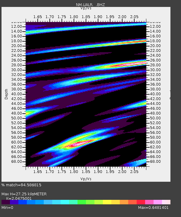
UALR University of Arkansas, Little Rock - Earthquake Result Viewer

Earthquake location: Northern Mid-Atlantic Ridge
Earthquake latitude/longitude: 23.9/-46.1
Earthquake time(UTC): 2009/06/06 (157) 20:33:28 GMT
Earthquake Depth: 14 km
Earthquake Magnitude: 6.0 MB, 5.7 MS, 6.0 MW, 6.0 MW
Earthquake Catalog/Contributor: WHDF/NEIC
Network: NM Cooperative New Madrid Seismic Network
Station: UALR University of Arkansas, Little Rock
Lat/Lon: 34.78 N/92.34 W
Elevation: 138 m
Distance: 41.4 deg
Az: 296.061 deg
Baz: 92.456 deg
Ray Param: 0.073781125
Estimated Moho Depth: 27.25 km
Estimated Crust Vp/Vs: 2.05
Assumed Crust Vp: 6.498 km/s
Estimated Crust Vs: 3.173 km/s
Estimated Crust Poisson's Ratio: 0.34
Radial Match: 94.586815 %
Radial Bump: 338
Transverse Match: 77.839294 %
Transverse Bump: 400
SOD ConfigId: 2648
Insert Time: 2010-03-09 11:36:17.299 +0000
GWidth: 2.5
Max Bumps: 400
Tol: 0.001

Signal To Noise

ChannelStoNSTALTA
NM:UALR: :BHZ:20090606T20:40:44.020002Z9.8482995.491897E-75.576493E-8
NM:UALR: :BHN:20090606T20:40:44.020002Z1.42198631.14663344E-78.0636035E-8
NM:UALR: :BHE:20090606T20:40:44.020002Z5.1208923.5386745E-76.91027E-8
Arrivals
Ps4.7 SECOND
PpPs12 SECOND
PsPs/PpSs17 SECOND