You are here: Home > Network List > IU - Global Seismograph Network (GSN - IRIS/USGS) Stations List
> Station PMG Port Moresby, New Guinea > Earthquake Result Viewer
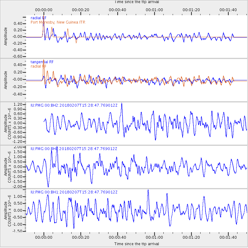
PMG Port Moresby, New Guinea - Earthquake Result Viewer
*The percent match for this event was below the threshold and hence no stack was calculated.
| Earthquake location: |
Taiwan |
| Earthquake latitude/longitude: |
24.1/121.7 |
| Earthquake time(UTC): |
2018/02/07 (038) 15:21:31 GMT |
| Earthquake Depth: |
11 km |
| Earthquake Magnitude: |
5.7 Mww |
| Earthquake Catalog/Contributor: |
NEIC PDE/us |
|
| Network: |
IU Global Seismograph Network (GSN - IRIS/USGS) |
| Station: |
PMG Port Moresby, New Guinea |
| Lat/Lon: |
9.40 S/147.16 E |
| Elevation: |
90 m |
|
| Distance: |
41.5 deg |
| Az: |
140.299 deg |
| Baz: |
323.729 deg |
| Ray Param: |
$rayparam |
*The percent match for this event was below the threshold and hence was not used in the summary stack. |
|
| Radial Match: |
60.94858 % |
| Radial Bump: |
400 |
| Transverse Match: |
61.26182 % |
| Transverse Bump: |
400 |
| SOD ConfigId: |
2546091 |
| Insert Time: |
2018-02-21 15:22:57.631 +0000 |
| GWidth: |
2.5 |
| Max Bumps: |
400 |
| Tol: |
0.001 |
|
Signal To Noise
| Channel | StoN | STA | LTA |
| IU:PMG:00:BHZ:20180207T15:28:47.769012Z | 2.839585 | 9.964851E-7 | 3.5092634E-7 |
| IU:PMG:00:BH1:20180207T15:28:47.769012Z | 2.3494012 | 6.174327E-7 | 2.628043E-7 |
| IU:PMG:00:BH2:20180207T15:28:47.769012Z | 0.9152037 | 3.063386E-7 | 3.347218E-7 |
| Arrivals |
| Ps | |
| PpPs | |
| PsPs/PpSs | |


