You are here: Home > Network List > NM - Cooperative New Madrid Seismic Network Stations List
> Station UALR University of Arkansas, Little Rock > Earthquake Result Viewer
UALR University of Arkansas, Little Rock - Earthquake Result Viewer
| Earthquake location: |
Kuril Islands |
| Earthquake latitude/longitude: |
46.6/153.3 |
| Earthquake time(UTC): |
2006/11/15 (319) 11:14:13 GMT |
| Earthquake Depth: |
10 km |
| Earthquake Magnitude: |
6.5 MB, 7.8 MS, 8.3 MW, 7.9 MW |
| Earthquake Catalog/Contributor: |
WHDF/NEIC |
|
| Network: |
NM Cooperative New Madrid Seismic Network |
| Station: |
UALR University of Arkansas, Little Rock |
| Lat/Lon: |
34.78 N/92.34 W |
| Elevation: |
138 m |
|
| Distance: |
79.8 deg |
| Az: |
49.615 deg |
| Baz: |
320.348 deg |
| Ray Param: |
0.04869893 |
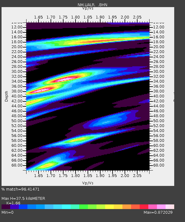
| Estimated Moho Depth: |
37.5 km |
| Estimated Crust Vp/Vs: |
1.66 |
| Assumed Crust Vp: |
6.498 km/s |
| Estimated Crust Vs: |
3.914 km/s |
| Estimated Crust Poisson's Ratio: |
0.22 |
|
| Radial Match: |
96.41471 % |
| Radial Bump: |
295 |
| Transverse Match: |
41.348446 % |
| Transverse Bump: |
400 |
| SOD ConfigId: |
2564 |
| Insert Time: |
2010-03-09 11:36:26.461 +0000 |
| GWidth: |
2.5 |
| Max Bumps: |
400 |
| Tol: |
0.001 |
|

Signal To Noise
| Channel | StoN | STA | LTA |
| NM:UALR: :BHN:20061115T11:25:50.635002Z | 0.3302277 | 9.2387563E-7 | 2.7976926E-6 |
| NM:UALR: :BHE:20061115T11:25:50.635002Z | 0.569692 | 1.6328214E-6 | 2.8661475E-6 |
| NM:UALR: :BHZ:20061115T11:25:50.635002Z | 13.51962 | 2.2418353E-6 | 1.658209E-7 |
| Arrivals |
| Ps | 3.9 SECOND |
| PpPs | 15 SECOND |
| PsPs/PpSs | 19 SECOND |


