You are here: Home > Network List > AK - Alaska Regional Network Stations List
> Station M16K Timber Creek, AK, USA > Earthquake Result Viewer
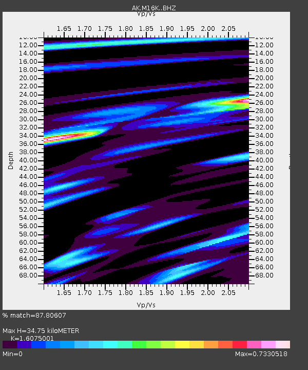
M16K Timber Creek, AK, USA - Earthquake Result Viewer
| Earthquake location: |
Tonga Islands Region |
| Earthquake latitude/longitude: |
-22.4/-174.6 |
| Earthquake time(UTC): |
2021/08/14 (226) 09:50:13 GMT |
| Earthquake Depth: |
10 km |
| Earthquake Magnitude: |
5.5 mww |
| Earthquake Catalog/Contributor: |
NEIC PDE/us |
|
| Network: |
AK Alaska Regional Network |
| Station: |
M16K Timber Creek, AK, USA |
| Lat/Lon: |
61.02 N/158.96 W |
| Elevation: |
394 m |
|
| Distance: |
84.1 deg |
| Az: |
7.561 deg |
| Baz: |
194.479 deg |
| Ray Param: |
0.045719814 |
| Estimated Moho Depth: |
34.75 km |
| Estimated Crust Vp/Vs: |
1.61 |
| Assumed Crust Vp: |
6.276 km/s |
| Estimated Crust Vs: |
3.904 km/s |
| Estimated Crust Poisson's Ratio: |
0.18 |
|
| Radial Match: |
87.80607 % |
| Radial Bump: |
336 |
| Transverse Match: |
79.75251 % |
| Transverse Bump: |
306 |
| SOD ConfigId: |
25131211 |
| Insert Time: |
2021-08-28 09:52:45.640 +0000 |
| GWidth: |
2.5 |
| Max Bumps: |
400 |
| Tol: |
0.001 |
|

Signal To Noise
| Channel | StoN | STA | LTA |
| AK:M16K: :BHZ:20210814T10:02:12.880009Z | 5.3200145 | 5.0510755E-7 | 9.494477E-8 |
| AK:M16K: :BHN:20210814T10:02:12.880009Z | 2.3141644 | 1.9980283E-7 | 8.6339085E-8 |
| AK:M16K: :BHE:20210814T10:02:12.880009Z | 1.0452528 | 9.171702E-8 | 8.774625E-8 |
| Arrivals |
| Ps | 3.5 SECOND |
| PpPs | 14 SECOND |
| PsPs/PpSs | 18 SECOND |


