You are here: Home > Network List > GS - US Geological Survey Networks Stations List
> Station DEC08 Union Local 159 Surface Site > Earthquake Result Viewer
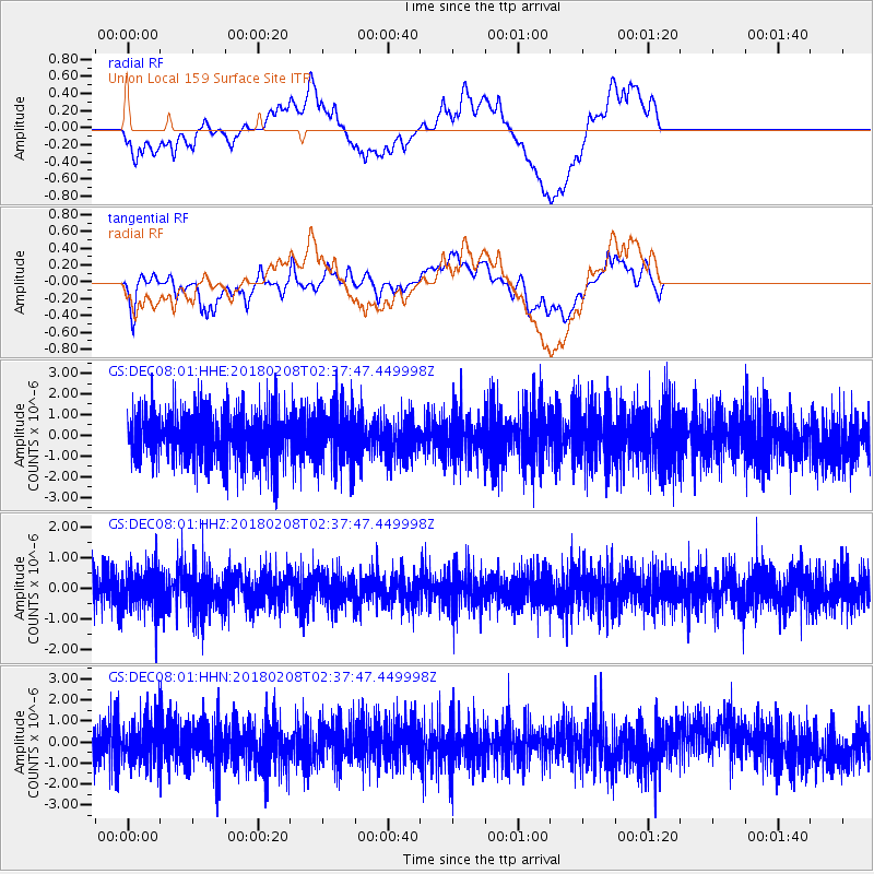
DEC08 Union Local 159 Surface Site - Earthquake Result Viewer
*The percent match for this event was below the threshold and hence no stack was calculated.
| Earthquake location: |
Greenland Sea |
| Earthquake latitude/longitude: |
79.8/2.0 |
| Earthquake time(UTC): |
2018/02/08 (039) 02:29:14 GMT |
| Earthquake Depth: |
10 km |
| Earthquake Magnitude: |
5.6 Mww |
| Earthquake Catalog/Contributor: |
NEIC PDE/us |
|
| Network: |
GS US Geological Survey Networks |
| Station: |
DEC08 Union Local 159 Surface Site |
| Lat/Lon: |
39.86 N/88.92 W |
| Elevation: |
210 m |
|
| Distance: |
51.3 deg |
| Az: |
279.323 deg |
| Baz: |
13.2 deg |
| Ray Param: |
$rayparam |
*The percent match for this event was below the threshold and hence was not used in the summary stack. |
|
| Radial Match: |
48.07175 % |
| Radial Bump: |
400 |
| Transverse Match: |
47.69014 % |
| Transverse Bump: |
400 |
| SOD ConfigId: |
2546091 |
| Insert Time: |
2018-02-22 02:32:58.044 +0000 |
| GWidth: |
2.5 |
| Max Bumps: |
400 |
| Tol: |
0.001 |
|
Signal To Noise
| Channel | StoN | STA | LTA |
| GS:DEC08:01:HHZ:20180208T02:37:47.449998Z | 1.2635624 | 6.8235835E-7 | 5.4002743E-7 |
| GS:DEC08:01:HHN:20180208T02:37:47.449998Z | 1.2271678 | 9.746301E-7 | 7.942109E-7 |
| GS:DEC08:01:HHE:20180208T02:37:47.449998Z | 1.100239 | 1.3855215E-6 | 1.2592914E-6 |
| Arrivals |
| Ps | |
| PpPs | |
| PsPs/PpSs | |


