You are here: Home > Network List > AV - Alaska Volcano Observatory Stations List
> Station R17L Mt. Peulik Volcano, AVO PLK4, AK, USA > Earthquake Result Viewer
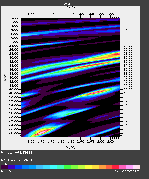
R17L Mt. Peulik Volcano, AVO PLK4, AK, USA - Earthquake Result Viewer
| Earthquake location: |
Tonga Islands Region |
| Earthquake latitude/longitude: |
-22.4/-174.6 |
| Earthquake time(UTC): |
2021/08/14 (226) 09:50:13 GMT |
| Earthquake Depth: |
10 km |
| Earthquake Magnitude: |
5.5 mww |
| Earthquake Catalog/Contributor: |
NEIC PDE/us |
|
| Network: |
AV Alaska Volcano Observatory |
| Station: |
R17L Mt. Peulik Volcano, AVO PLK4, AK, USA |
| Lat/Lon: |
57.63 N/156.36 W |
| Elevation: |
524 m |
|
| Distance: |
81.2 deg |
| Az: |
9.784 deg |
| Baz: |
196.996 deg |
| Ray Param: |
0.047767285 |
| Estimated Moho Depth: |
67.5 km |
| Estimated Crust Vp/Vs: |
1.70 |
| Assumed Crust Vp: |
6.1 km/s |
| Estimated Crust Vs: |
3.588 km/s |
| Estimated Crust Poisson's Ratio: |
0.24 |
|
| Radial Match: |
94.85684 % |
| Radial Bump: |
213 |
| Transverse Match: |
58.199543 % |
| Transverse Bump: |
400 |
| SOD ConfigId: |
25131211 |
| Insert Time: |
2021-08-28 09:55:57.586 +0000 |
| GWidth: |
2.5 |
| Max Bumps: |
400 |
| Tol: |
0.001 |
|

Signal To Noise
| Channel | StoN | STA | LTA |
| AV:R17L: :BHZ:20210814T10:01:57.775028Z | 2.3593094 | 3.9293897E-7 | 1.6654832E-7 |
| AV:R17L: :BHN:20210814T10:01:57.775028Z | 2.2392712 | 2.5542678E-7 | 1.14066935E-7 |
| AV:R17L: :BHE:20210814T10:01:57.775028Z | 1.4839226 | 2.3784646E-7 | 1.6028226E-7 |
| Arrivals |
| Ps | 7.9 SECOND |
| PpPs | 29 SECOND |
| PsPs/PpSs | 37 SECOND |


