You are here: Home > Network List > CI - Caltech Regional Seismic Network Stations List
> Station LRL Laurel Mtn Radio Fac, Ridgecrest, CA, USA > Earthquake Result Viewer
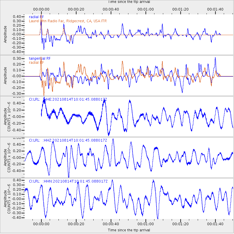
LRL Laurel Mtn Radio Fac, Ridgecrest, CA, USA - Earthquake Result Viewer
*The percent match for this event was below the threshold and hence no stack was calculated.
| Earthquake location: |
Tonga Islands Region |
| Earthquake latitude/longitude: |
-22.4/-174.6 |
| Earthquake time(UTC): |
2021/08/14 (226) 09:50:13 GMT |
| Earthquake Depth: |
10 km |
| Earthquake Magnitude: |
5.5 mww |
| Earthquake Catalog/Contributor: |
NEIC PDE/us |
|
| Network: |
CI Caltech Regional Seismic Network |
| Station: |
LRL Laurel Mtn Radio Fac, Ridgecrest, CA, USA |
| Lat/Lon: |
35.48 N/117.68 W |
| Elevation: |
1340 m |
|
| Distance: |
78.8 deg |
| Az: |
44.159 deg |
| Baz: |
232.167 deg |
| Ray Param: |
$rayparam |
*The percent match for this event was below the threshold and hence was not used in the summary stack. |
|
| Radial Match: |
49.354057 % |
| Radial Bump: |
400 |
| Transverse Match: |
45.424923 % |
| Transverse Bump: |
400 |
| SOD ConfigId: |
25131211 |
| Insert Time: |
2021-08-28 09:59:19.806 +0000 |
| GWidth: |
2.5 |
| Max Bumps: |
400 |
| Tol: |
0.001 |
|
Signal To Noise
| Channel | StoN | STA | LTA |
| CI:LRL: :HHZ:20210814T10:01:45.088017Z | 2.7108688 | 2.8271066E-7 | 1.0428784E-7 |
| CI:LRL: :HHN:20210814T10:01:45.088017Z | 1.3851469 | 2.4561314E-7 | 1.773192E-7 |
| CI:LRL: :HHE:20210814T10:01:45.088017Z | 1.5191715 | 2.4193056E-7 | 1.5925164E-7 |
| Arrivals |
| Ps | |
| PpPs | |
| PsPs/PpSs | |


