You are here: Home > Network List > CN - Canadian National Seismograph Network Stations List
> Station INK INUVIK, NT > Earthquake Result Viewer
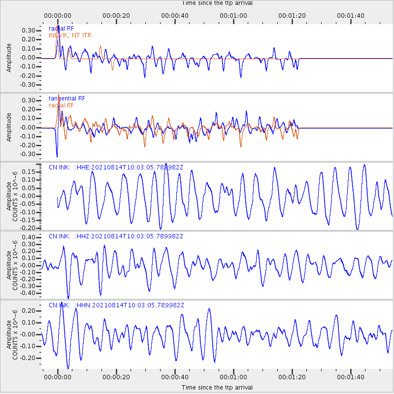
INK INUVIK, NT - Earthquake Result Viewer
*The percent match for this event was below the threshold and hence no stack was calculated.
| Earthquake location: |
Tonga Islands Region |
| Earthquake latitude/longitude: |
-22.4/-174.6 |
| Earthquake time(UTC): |
2021/08/14 (226) 09:50:13 GMT |
| Earthquake Depth: |
10 km |
| Earthquake Magnitude: |
5.5 mww |
| Earthquake Catalog/Contributor: |
NEIC PDE/us |
|
| Network: |
CN Canadian National Seismograph Network |
| Station: |
INK INUVIK, NT |
| Lat/Lon: |
68.31 N/133.53 W |
| Elevation: |
44 m |
|
| Distance: |
95.3 deg |
| Az: |
14.187 deg |
| Baz: |
217.588 deg |
| Ray Param: |
$rayparam |
*The percent match for this event was below the threshold and hence was not used in the summary stack. |
|
| Radial Match: |
70.138336 % |
| Radial Bump: |
351 |
| Transverse Match: |
47.531845 % |
| Transverse Bump: |
400 |
| SOD ConfigId: |
25131211 |
| Insert Time: |
2021-08-28 10:00:09.808 +0000 |
| GWidth: |
2.5 |
| Max Bumps: |
400 |
| Tol: |
0.001 |
|
Signal To Noise
| Channel | StoN | STA | LTA |
| CN:INK: :HHZ:20210814T10:03:05.789982Z | 1.6465935 | 2.0199651E-7 | 1.226754E-7 |
| CN:INK: :HHN:20210814T10:03:05.789982Z | 3.4620621 | 1.7484277E-7 | 5.0502493E-8 |
| CN:INK: :HHE:20210814T10:03:05.789982Z | 1.2909038 | 1.06092955E-7 | 8.218502E-8 |
| Arrivals |
| Ps | |
| PpPs | |
| PsPs/PpSs | |


