You are here: Home > Network List > AE - Arizona Broadband Seismic Network Stations List
> Station TONTO Roosevelt/Tonto Basin > Earthquake Result Viewer
TONTO Roosevelt/Tonto Basin - Earthquake Result Viewer
| Earthquake location: |
Alaska Peninsula |
| Earthquake latitude/longitude: |
55.2/-157.7 |
| Earthquake time(UTC): |
2021/08/14 (226) 11:57:42 GMT |
| Earthquake Depth: |
4.8 km |
| Earthquake Magnitude: |
6.4 ml |
| Earthquake Catalog/Contributor: |
NEIC PDE/ak |
|
| Network: |
AE Arizona Broadband Seismic Network |
| Station: |
TONTO Roosevelt/Tonto Basin |
| Lat/Lon: |
33.65 N/111.01 W |
| Elevation: |
661 m |
|
| Distance: |
38.8 deg |
| Az: |
104.15 deg |
| Baz: |
318.255 deg |
| Ray Param: |
0.07541744 |
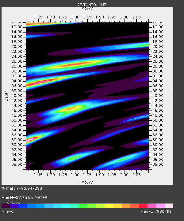
| Estimated Moho Depth: |
57.75 km |
| Estimated Crust Vp/Vs: |
1.61 |
| Assumed Crust Vp: |
6.276 km/s |
| Estimated Crust Vs: |
3.898 km/s |
| Estimated Crust Poisson's Ratio: |
0.19 |
|
| Radial Match: |
90.947296 % |
| Radial Bump: |
400 |
| Transverse Match: |
79.791084 % |
| Transverse Bump: |
400 |
| SOD ConfigId: |
25131211 |
| Insert Time: |
2021-08-28 11:58:26.580 +0000 |
| GWidth: |
2.5 |
| Max Bumps: |
400 |
| Tol: |
0.001 |
|

Signal To Noise
| Channel | StoN | STA | LTA |
| AE:TONTO: :HHZ:20210814T12:04:37.118986Z | 40.945427 | 4.800032E-6 | 1.1722999E-7 |
| AE:TONTO: :HHN:20210814T12:04:37.118986Z | 14.752074 | 2.506477E-6 | 1.6990676E-7 |
| AE:TONTO: :HHE:20210814T12:04:37.118986Z | 15.407075 | 2.048036E-6 | 1.3292829E-7 |
| Arrivals |
| Ps | 6.1 SECOND |
| PpPs | 22 SECOND |
| PsPs/PpSs | 28 SECOND |


