You are here: Home > Network List > US - United States National Seismic Network Stations List
> Station BW06 Boulder Array Site 6 (Pinedale), Wyoming, USA > Earthquake Result Viewer
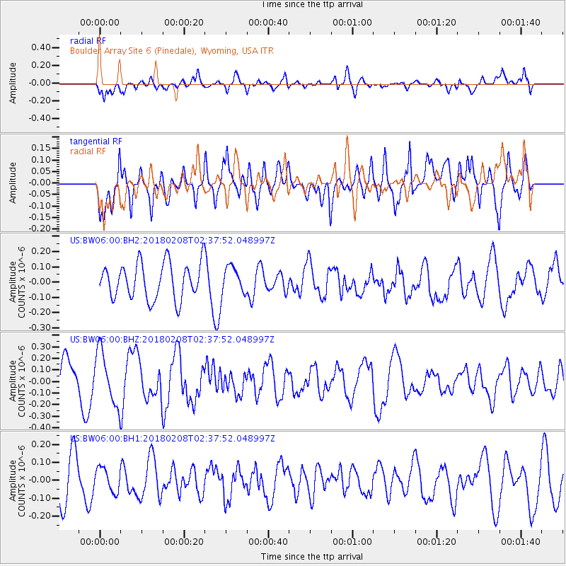
BW06 Boulder Array Site 6 (Pinedale), Wyoming, USA - Earthquake Result Viewer
*The percent match for this event was below the threshold and hence no stack was calculated.
| Earthquake location: |
Greenland Sea |
| Earthquake latitude/longitude: |
79.8/2.0 |
| Earthquake time(UTC): |
2018/02/08 (039) 02:29:14 GMT |
| Earthquake Depth: |
10 km |
| Earthquake Magnitude: |
5.6 Mww |
| Earthquake Catalog/Contributor: |
NEIC PDE/us |
|
| Network: |
US United States National Seismic Network |
| Station: |
BW06 Boulder Array Site 6 (Pinedale), Wyoming, USA |
| Lat/Lon: |
42.77 N/109.56 W |
| Elevation: |
2224 m |
|
| Distance: |
51.9 deg |
| Az: |
299.482 deg |
| Baz: |
12.155 deg |
| Ray Param: |
$rayparam |
*The percent match for this event was below the threshold and hence was not used in the summary stack. |
|
| Radial Match: |
52.42433 % |
| Radial Bump: |
400 |
| Transverse Match: |
62.071953 % |
| Transverse Bump: |
400 |
| SOD ConfigId: |
2546091 |
| Insert Time: |
2018-02-22 02:35:38.613 +0000 |
| GWidth: |
2.5 |
| Max Bumps: |
400 |
| Tol: |
0.001 |
|
Signal To Noise
| Channel | StoN | STA | LTA |
| US:BW06:00:BHZ:20180208T02:37:52.048997Z | 1.5033705 | 2.3690518E-7 | 1.575827E-7 |
| US:BW06:00:BH1:20180208T02:37:52.048997Z | 0.5776775 | 6.710126E-8 | 1.1615697E-7 |
| US:BW06:00:BH2:20180208T02:37:52.048997Z | 0.6993705 | 8.2146336E-8 | 1.1745754E-7 |
| Arrivals |
| Ps | |
| PpPs | |
| PsPs/PpSs | |


