You are here: Home > Network List > BC - Red Sismica del Noroeste de Mexico Stations List
> Station CBX CERRO BOLA MEX, , , MEXICO > Earthquake Result Viewer
CBX CERRO BOLA MEX, , , MEXICO - Earthquake Result Viewer
| Earthquake location: |
Alaska Peninsula |
| Earthquake latitude/longitude: |
55.2/-157.7 |
| Earthquake time(UTC): |
2021/08/14 (226) 11:57:42 GMT |
| Earthquake Depth: |
4.8 km |
| Earthquake Magnitude: |
6.4 ml |
| Earthquake Catalog/Contributor: |
NEIC PDE/ak |
|
| Network: |
BC Red Sismica del Noroeste de Mexico |
| Station: |
CBX CERRO BOLA MEX, , , MEXICO |
| Lat/Lon: |
32.31 N/116.66 W |
| Elevation: |
1250 m |
|
| Distance: |
36.7 deg |
| Az: |
111.48 deg |
| Baz: |
320.99 deg |
| Ray Param: |
0.07658568 |
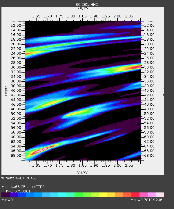
| Estimated Moho Depth: |
65.25 km |
| Estimated Crust Vp/Vs: |
1.68 |
| Assumed Crust Vp: |
6.264 km/s |
| Estimated Crust Vs: |
3.739 km/s |
| Estimated Crust Poisson's Ratio: |
0.22 |
|
| Radial Match: |
84.76451 % |
| Radial Bump: |
297 |
| Transverse Match: |
61.079914 % |
| Transverse Bump: |
400 |
| SOD ConfigId: |
25131211 |
| Insert Time: |
2021-08-28 11:59:15.181 +0000 |
| GWidth: |
2.5 |
| Max Bumps: |
400 |
| Tol: |
0.001 |
|

Signal To Noise
| Channel | StoN | STA | LTA |
| BC:CBX: :HHZ:20210814T12:04:19.649991Z | 35.36816 | 6.640155E-6 | 1.8774385E-7 |
| BC:CBX: :HHN:20210814T12:04:19.649991Z | 12.4452 | 3.6977267E-6 | 2.9712072E-7 |
| BC:CBX: :HHE:20210814T12:04:19.649991Z | 8.080704 | 3.187801E-6 | 3.944955E-7 |
| Arrivals |
| Ps | 7.6 SECOND |
| PpPs | 26 SECOND |
| PsPs/PpSs | 33 SECOND |


