You are here: Home > Network List > CA - Catalan Seismic Network Stations List
> Station CGAR Garraf > Earthquake Result Viewer
CGAR Garraf - Earthquake Result Viewer
| Earthquake location: |
Alaska Peninsula |
| Earthquake latitude/longitude: |
55.2/-157.7 |
| Earthquake time(UTC): |
2021/08/14 (226) 11:57:42 GMT |
| Earthquake Depth: |
4.8 km |
| Earthquake Magnitude: |
6.4 ml |
| Earthquake Catalog/Contributor: |
NEIC PDE/ak |
|
| Network: |
CA Catalan Seismic Network |
| Station: |
CGAR Garraf |
| Lat/Lon: |
41.29 N/1.91 E |
| Elevation: |
584 m |
|
| Distance: |
82.3 deg |
| Az: |
15.355 deg |
| Baz: |
348.388 deg |
| Ray Param: |
0.04700827 |
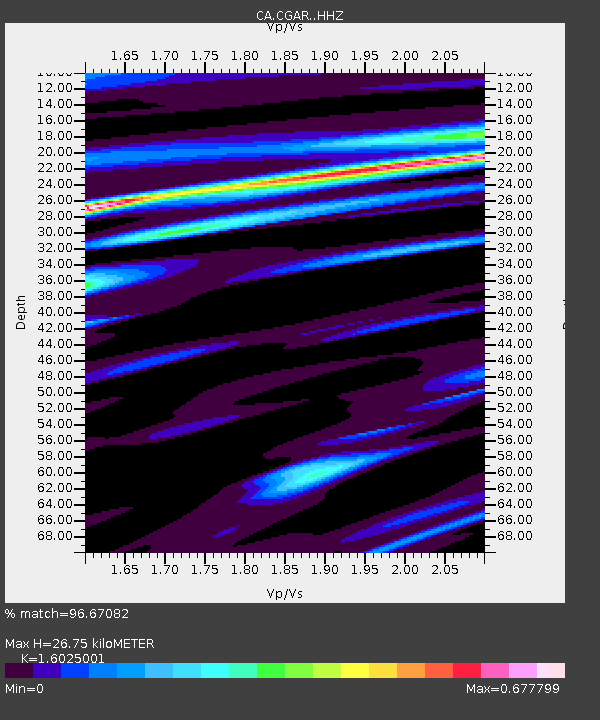
| Estimated Moho Depth: |
26.75 km |
| Estimated Crust Vp/Vs: |
1.60 |
| Assumed Crust Vp: |
6.391 km/s |
| Estimated Crust Vs: |
3.988 km/s |
| Estimated Crust Poisson's Ratio: |
0.18 |
|
| Radial Match: |
96.67082 % |
| Radial Bump: |
321 |
| Transverse Match: |
83.45182 % |
| Transverse Bump: |
400 |
| SOD ConfigId: |
25131211 |
| Insert Time: |
2021-08-28 12:00:19.318 +0000 |
| GWidth: |
2.5 |
| Max Bumps: |
400 |
| Tol: |
0.001 |
|
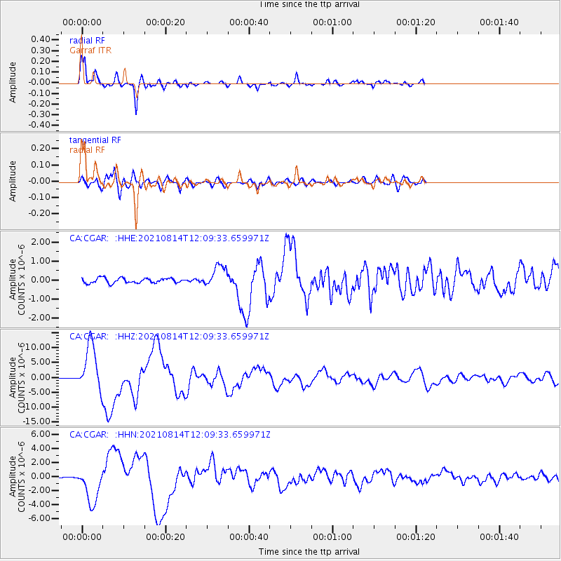
Signal To Noise
| Channel | StoN | STA | LTA |
| CA:CGAR: :HHZ:20210814T12:09:33.659971Z | 70.18578 | 8.084298E-6 | 1.1518428E-7 |
| CA:CGAR: :HHN:20210814T12:09:33.659971Z | 19.297125 | 2.6730243E-6 | 1.385193E-7 |
| CA:CGAR: :HHE:20210814T12:09:33.659971Z | 4.429433 | 5.763529E-7 | 1.3011889E-7 |
| Arrivals |
| Ps | 2.6 SECOND |
| PpPs | 11 SECOND |
| PsPs/PpSs | 13 SECOND |


