You are here: Home > Network List > CA - Catalan Seismic Network Stations List
> Station CLLI Llivia > Earthquake Result Viewer
CLLI Llivia - Earthquake Result Viewer
| Earthquake location: |
Alaska Peninsula |
| Earthquake latitude/longitude: |
55.2/-157.7 |
| Earthquake time(UTC): |
2021/08/14 (226) 11:57:42 GMT |
| Earthquake Depth: |
4.8 km |
| Earthquake Magnitude: |
6.4 ml |
| Earthquake Catalog/Contributor: |
NEIC PDE/ak |
|
| Network: |
CA Catalan Seismic Network |
| Station: |
CLLI Llivia |
| Lat/Lon: |
42.48 N/1.97 E |
| Elevation: |
1413 m |
|
| Distance: |
81.1 deg |
| Az: |
15.071 deg |
| Baz: |
348.386 deg |
| Ray Param: |
0.0478167 |
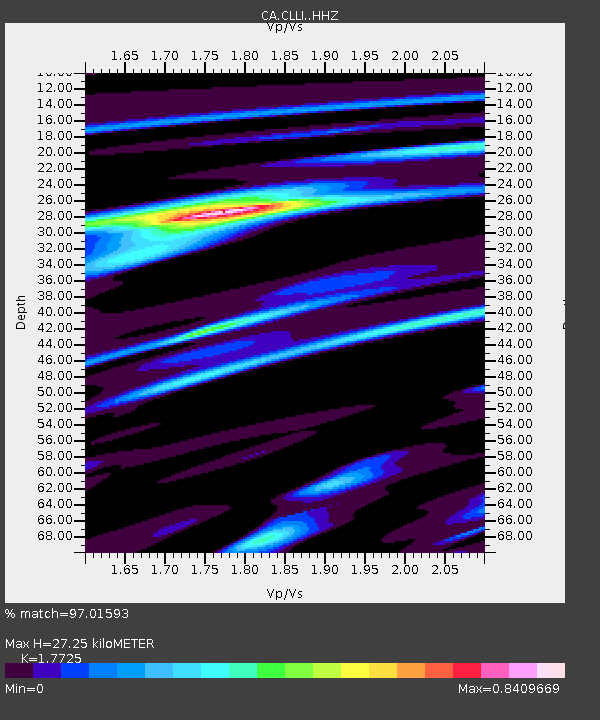
| Estimated Moho Depth: |
27.25 km |
| Estimated Crust Vp/Vs: |
1.77 |
| Assumed Crust Vp: |
6.416 km/s |
| Estimated Crust Vs: |
3.62 km/s |
| Estimated Crust Poisson's Ratio: |
0.27 |
|
| Radial Match: |
97.01593 % |
| Radial Bump: |
319 |
| Transverse Match: |
88.44827 % |
| Transverse Bump: |
400 |
| SOD ConfigId: |
25131211 |
| Insert Time: |
2021-08-28 12:00:22.422 +0000 |
| GWidth: |
2.5 |
| Max Bumps: |
400 |
| Tol: |
0.001 |
|

Signal To Noise
| Channel | StoN | STA | LTA |
| CA:CLLI: :HHZ:20210814T12:09:27.609983Z | 70.62248 | 6.834726E-6 | 9.677833E-8 |
| CA:CLLI: :HHN:20210814T12:09:27.609983Z | 28.18301 | 2.3455752E-6 | 8.322657E-8 |
| CA:CLLI: :HHE:20210814T12:09:27.609983Z | 13.606534 | 1.0073195E-6 | 7.4032044E-8 |
| Arrivals |
| Ps | 3.4 SECOND |
| PpPs | 11 SECOND |
| PsPs/PpSs | 15 SECOND |


