You are here: Home > Network List > CA - Catalan Seismic Network Stations List
> Station CSOR Soriguera > Earthquake Result Viewer
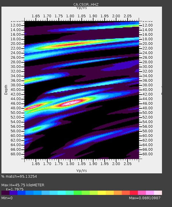
CSOR Soriguera - Earthquake Result Viewer
| Earthquake location: |
Alaska Peninsula |
| Earthquake latitude/longitude: |
55.2/-157.7 |
| Earthquake time(UTC): |
2021/08/14 (226) 11:57:42 GMT |
| Earthquake Depth: |
4.8 km |
| Earthquake Magnitude: |
6.4 ml |
| Earthquake Catalog/Contributor: |
NEIC PDE/ak |
|
| Network: |
CA Catalan Seismic Network |
| Station: |
CSOR Soriguera |
| Lat/Lon: |
42.37 N/1.13 E |
| Elevation: |
1227 m |
|
| Distance: |
81.1 deg |
| Az: |
15.709 deg |
| Baz: |
347.92 deg |
| Ray Param: |
0.047834765 |
| Estimated Moho Depth: |
45.75 km |
| Estimated Crust Vp/Vs: |
1.80 |
| Assumed Crust Vp: |
6.416 km/s |
| Estimated Crust Vs: |
3.569 km/s |
| Estimated Crust Poisson's Ratio: |
0.28 |
|
| Radial Match: |
95.13254 % |
| Radial Bump: |
400 |
| Transverse Match: |
90.672935 % |
| Transverse Bump: |
400 |
| SOD ConfigId: |
25131211 |
| Insert Time: |
2021-08-28 12:00:27.999 +0000 |
| GWidth: |
2.5 |
| Max Bumps: |
400 |
| Tol: |
0.001 |
|

Signal To Noise
| Channel | StoN | STA | LTA |
| CA:CSOR: :HHZ:20210814T12:09:27.470029Z | 61.09196 | 6.889129E-6 | 1.12766536E-7 |
| CA:CSOR: :HHN:20210814T12:09:27.470029Z | 24.828228 | 1.9600554E-6 | 7.894464E-8 |
| CA:CSOR: :HHE:20210814T12:09:27.470029Z | 10.921887 | 6.1201484E-7 | 5.6035628E-8 |
| Arrivals |
| Ps | 5.8 SECOND |
| PpPs | 19 SECOND |
| PsPs/PpSs | 25 SECOND |


