You are here: Home > Network List > CI - Caltech Regional Seismic Network Stations List
> Station GRA Grapevine Ranger Station, Death Valley, CA, USA > Earthquake Result Viewer
GRA Grapevine Ranger Station, Death Valley, CA, USA - Earthquake Result Viewer

| Earthquake location: |
Alaska Peninsula |
| Earthquake latitude/longitude: |
55.2/-157.7 |
| Earthquake time(UTC): |
2021/08/14 (226) 11:57:42 GMT |
| Earthquake Depth: |
4.8 km |
| Earthquake Magnitude: |
6.4 ml |
| Earthquake Catalog/Contributor: |
NEIC PDE/ak |
|
| Network: |
CI Caltech Regional Seismic Network |
| Station: |
GRA Grapevine Ranger Station, Death Valley, CA, USA |
| Lat/Lon: |
37.00 N/117.37 W |
| Elevation: |
689 m |
|
| Distance: |
32.8 deg |
| Az: |
106.855 deg |
| Baz: |
316.789 deg |
| Ray Param: |
0.078518726 |
| Estimated Moho Depth: |
38.5 km |
| Estimated Crust Vp/Vs: |
1.89 |
| Assumed Crust Vp: |
6.279 km/s |
| Estimated Crust Vs: |
3.326 km/s |
| Estimated Crust Poisson's Ratio: |
0.30 |
|
| Radial Match: |
88.5647 % |
| Radial Bump: |
225 |
| Transverse Match: |
73.39219 % |
| Transverse Bump: |
400 |
| SOD ConfigId: |
25131211 |
| Insert Time: |
2021-08-28 12:01:24.232 +0000 |
| GWidth: |
2.5 |
| Max Bumps: |
400 |
| Tol: |
0.001 |
|
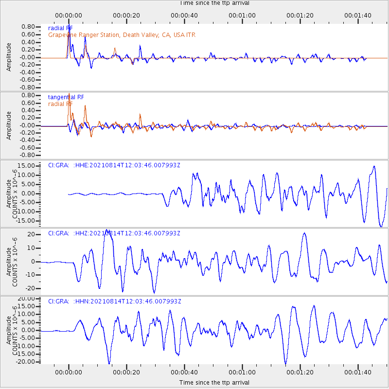
Signal To Noise
| Channel | StoN | STA | LTA |
| CI:GRA: :HHZ:20210814T12:03:46.007993Z | 47.20201 | 6.9488224E-6 | 1.4721454E-7 |
| CI:GRA: :HHN:20210814T12:03:46.007993Z | 20.460524 | 3.4132636E-6 | 1.668219E-7 |
| CI:GRA: :HHE:20210814T12:03:46.007993Z | 9.667972 | 3.1105299E-6 | 3.217355E-7 |
| Arrivals |
| Ps | 5.8 SECOND |
| PpPs | 17 SECOND |
| PsPs/PpSs | 22 SECOND |


