You are here: Home > Network List > CI - Caltech Regional Seismic Network Stations List
> Station SDD Saddleback, Mission Viejo, CA, USA > Earthquake Result Viewer
SDD Saddleback, Mission Viejo, CA, USA - Earthquake Result Viewer
| Earthquake location: |
Alaska Peninsula |
| Earthquake latitude/longitude: |
55.2/-157.7 |
| Earthquake time(UTC): |
2021/08/14 (226) 11:57:42 GMT |
| Earthquake Depth: |
4.8 km |
| Earthquake Magnitude: |
6.4 ml |
| Earthquake Catalog/Contributor: |
NEIC PDE/ak |
|
| Network: |
CI Caltech Regional Seismic Network |
| Station: |
SDD Saddleback, Mission Viejo, CA, USA |
| Lat/Lon: |
33.55 N/117.66 W |
| Elevation: |
120 m |
|
| Distance: |
35.2 deg |
| Az: |
111.25 deg |
| Baz: |
320.263 deg |
| Ray Param: |
0.07736318 |
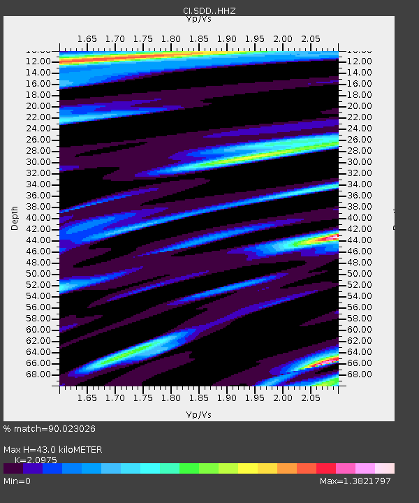
| Estimated Moho Depth: |
43.0 km |
| Estimated Crust Vp/Vs: |
2.10 |
| Assumed Crust Vp: |
6.264 km/s |
| Estimated Crust Vs: |
2.986 km/s |
| Estimated Crust Poisson's Ratio: |
0.35 |
|
| Radial Match: |
90.023026 % |
| Radial Bump: |
400 |
| Transverse Match: |
79.736244 % |
| Transverse Bump: |
400 |
| SOD ConfigId: |
25131211 |
| Insert Time: |
2021-08-28 12:02:06.648 +0000 |
| GWidth: |
2.5 |
| Max Bumps: |
400 |
| Tol: |
0.001 |
|
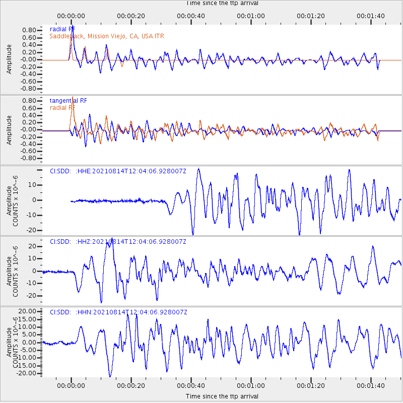
Signal To Noise
| Channel | StoN | STA | LTA |
| CI:SDD: :HHZ:20210814T12:04:06.928007Z | 11.328839 | 7.801266E-6 | 6.8862005E-7 |
| CI:SDD: :HHN:20210814T12:04:06.928007Z | 6.941119 | 5.037642E-6 | 7.2576796E-7 |
| CI:SDD: :HHE:20210814T12:04:06.928007Z | 9.641875 | 4.1830494E-6 | 4.338419E-7 |
| Arrivals |
| Ps | 8.0 SECOND |
| PpPs | 20 SECOND |
| PsPs/PpSs | 28 SECOND |


