You are here: Home > Network List > CN - Canadian National Seismograph Network Stations List
> Station KAPO KAPUSKASING, ON > Earthquake Result Viewer
KAPO KAPUSKASING, ON - Earthquake Result Viewer
| Earthquake location: |
Alaska Peninsula |
| Earthquake latitude/longitude: |
55.2/-157.7 |
| Earthquake time(UTC): |
2021/08/14 (226) 11:57:42 GMT |
| Earthquake Depth: |
4.8 km |
| Earthquake Magnitude: |
6.4 ml |
| Earthquake Catalog/Contributor: |
NEIC PDE/ak |
|
| Network: |
CN Canadian National Seismograph Network |
| Station: |
KAPO KAPUSKASING, ON |
| Lat/Lon: |
49.45 N/82.51 W |
| Elevation: |
210 m |
|
| Distance: |
44.2 deg |
| Az: |
64.77 deg |
| Baz: |
307.446 deg |
| Ray Param: |
0.07207604 |
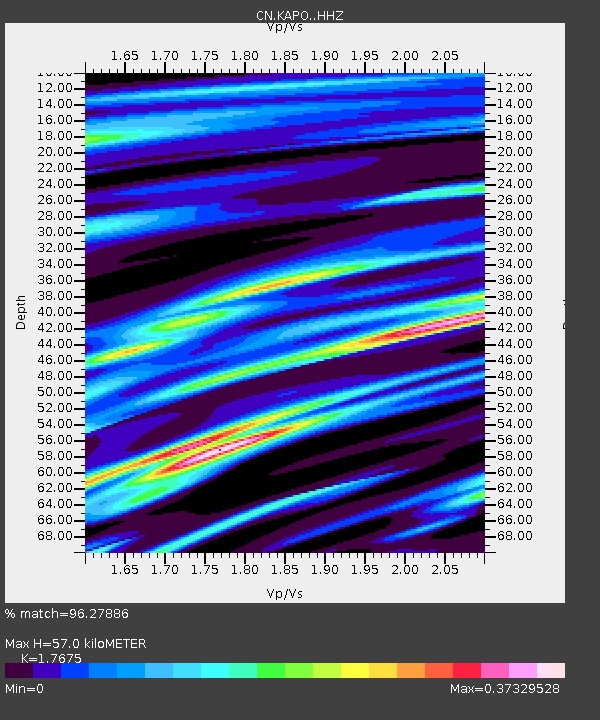
| Estimated Moho Depth: |
57.0 km |
| Estimated Crust Vp/Vs: |
1.77 |
| Assumed Crust Vp: |
6.467 km/s |
| Estimated Crust Vs: |
3.659 km/s |
| Estimated Crust Poisson's Ratio: |
0.26 |
|
| Radial Match: |
96.27886 % |
| Radial Bump: |
236 |
| Transverse Match: |
86.55441 % |
| Transverse Bump: |
400 |
| SOD ConfigId: |
25131211 |
| Insert Time: |
2021-08-28 12:03:14.746 +0000 |
| GWidth: |
2.5 |
| Max Bumps: |
400 |
| Tol: |
0.001 |
|

Signal To Noise
| Channel | StoN | STA | LTA |
| CN:KAPO: :HHZ:20210814T12:05:21.899991Z | 33.447224 | 5.171478E-6 | 1.5461605E-7 |
| CN:KAPO: :HHN:20210814T12:05:21.899991Z | 11.592135 | 1.1275707E-6 | 9.727032E-8 |
| CN:KAPO: :HHE:20210814T12:05:21.899991Z | 28.0595 | 2.6591306E-6 | 9.476757E-8 |
| Arrivals |
| Ps | 7.2 SECOND |
| PpPs | 23 SECOND |
| PsPs/PpSs | 30 SECOND |


