You are here: Home > Network List > CN - Canadian National Seismograph Network Stations List
> Station KILO Kirkland Lake, ON, CA > Earthquake Result Viewer
KILO Kirkland Lake, ON, CA - Earthquake Result Viewer
| Earthquake location: |
Alaska Peninsula |
| Earthquake latitude/longitude: |
55.2/-157.7 |
| Earthquake time(UTC): |
2021/08/14 (226) 11:57:42 GMT |
| Earthquake Depth: |
4.8 km |
| Earthquake Magnitude: |
6.4 ml |
| Earthquake Catalog/Contributor: |
NEIC PDE/ak |
|
| Network: |
CN Canadian National Seismograph Network |
| Station: |
KILO Kirkland Lake, ON, CA |
| Lat/Lon: |
48.50 N/79.72 W |
| Elevation: |
314 m |
|
| Distance: |
46.3 deg |
| Az: |
64.223 deg |
| Baz: |
309.156 deg |
| Ray Param: |
0.070785016 |
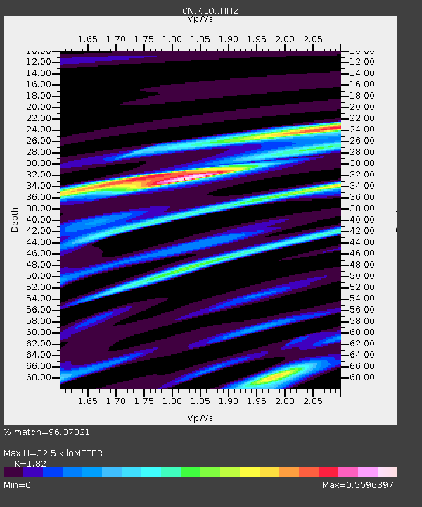
| Estimated Moho Depth: |
32.5 km |
| Estimated Crust Vp/Vs: |
1.82 |
| Assumed Crust Vp: |
6.61 km/s |
| Estimated Crust Vs: |
3.632 km/s |
| Estimated Crust Poisson's Ratio: |
0.28 |
|
| Radial Match: |
96.37321 % |
| Radial Bump: |
255 |
| Transverse Match: |
84.52358 % |
| Transverse Bump: |
400 |
| SOD ConfigId: |
25131211 |
| Insert Time: |
2021-08-28 12:03:17.103 +0000 |
| GWidth: |
2.5 |
| Max Bumps: |
400 |
| Tol: |
0.001 |
|

Signal To Noise
| Channel | StoN | STA | LTA |
| CN:KILO: :HHZ:20210814T12:05:38.010007Z | 29.524353 | 4.9220293E-6 | 1.6671082E-7 |
| CN:KILO: :HHN:20210814T12:05:38.010007Z | 16.096886 | 1.8935139E-6 | 1.1763232E-7 |
| CN:KILO: :HHE:20210814T12:05:38.010007Z | 13.608224 | 1.831038E-6 | 1.3455379E-7 |
| Arrivals |
| Ps | 4.3 SECOND |
| PpPs | 13 SECOND |
| PsPs/PpSs | 17 SECOND |


