You are here: Home > Network List > CN - Canadian National Seismograph Network Stations List
> Station KIPQ Kipawa, QC, CA > Earthquake Result Viewer
KIPQ Kipawa, QC, CA - Earthquake Result Viewer
| Earthquake location: |
Alaska Peninsula |
| Earthquake latitude/longitude: |
55.2/-157.7 |
| Earthquake time(UTC): |
2021/08/14 (226) 11:57:42 GMT |
| Earthquake Depth: |
4.8 km |
| Earthquake Magnitude: |
6.4 ml |
| Earthquake Catalog/Contributor: |
NEIC PDE/ak |
|
| Network: |
CN Canadian National Seismograph Network |
| Station: |
KIPQ Kipawa, QC, CA |
| Lat/Lon: |
46.79 N/79.06 W |
| Elevation: |
274 m |
|
| Distance: |
47.7 deg |
| Az: |
65.618 deg |
| Baz: |
310.599 deg |
| Ray Param: |
0.069852844 |
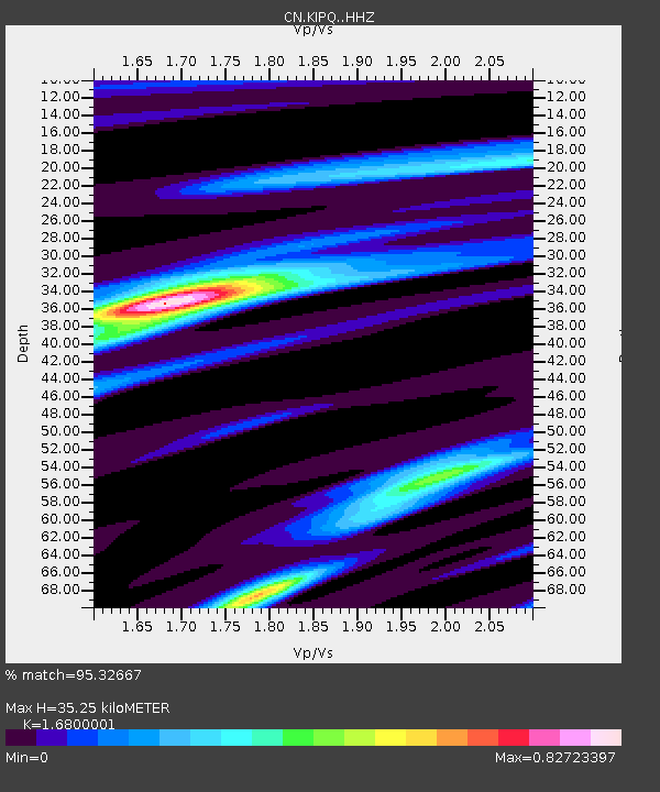
| Estimated Moho Depth: |
35.25 km |
| Estimated Crust Vp/Vs: |
1.68 |
| Assumed Crust Vp: |
6.622 km/s |
| Estimated Crust Vs: |
3.942 km/s |
| Estimated Crust Poisson's Ratio: |
0.23 |
|
| Radial Match: |
95.32667 % |
| Radial Bump: |
247 |
| Transverse Match: |
68.37772 % |
| Transverse Bump: |
400 |
| SOD ConfigId: |
25131211 |
| Insert Time: |
2021-08-28 12:03:17.322 +0000 |
| GWidth: |
2.5 |
| Max Bumps: |
400 |
| Tol: |
0.001 |
|

Signal To Noise
| Channel | StoN | STA | LTA |
| CN:KIPQ: :HHZ:20210814T12:05:49.249998Z | 24.027729 | 5.200091E-6 | 2.1642039E-7 |
| CN:KIPQ: :HHN:20210814T12:05:49.249998Z | 12.575706 | 1.4487493E-6 | 1.15202226E-7 |
| CN:KIPQ: :HHE:20210814T12:05:49.249998Z | 24.039488 | 1.9767285E-6 | 8.22284E-8 |
| Arrivals |
| Ps | 3.9 SECOND |
| PpPs | 13 SECOND |
| PsPs/PpSs | 17 SECOND |


