You are here: Home > Network List > CU - Caribbean Network (USGS) Stations List
> Station GTBY Guantanamo Bay, Cuba > Earthquake Result Viewer
GTBY Guantanamo Bay, Cuba - Earthquake Result Viewer
| Earthquake location: |
Alaska Peninsula |
| Earthquake latitude/longitude: |
55.2/-157.7 |
| Earthquake time(UTC): |
2021/08/14 (226) 11:57:42 GMT |
| Earthquake Depth: |
4.8 km |
| Earthquake Magnitude: |
6.4 ml |
| Earthquake Catalog/Contributor: |
NEIC PDE/ak |
|
| Network: |
CU Caribbean Network (USGS) |
| Station: |
GTBY Guantanamo Bay, Cuba |
| Lat/Lon: |
19.93 N/75.11 W |
| Elevation: |
79 m |
|
| Distance: |
69.7 deg |
| Az: |
84.206 deg |
| Baz: |
322.723 deg |
| Ray Param: |
0.05549453 |
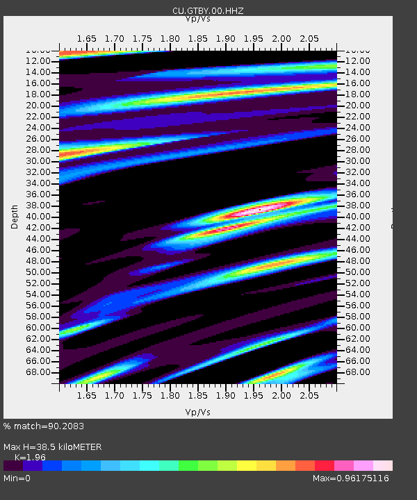
| Estimated Moho Depth: |
38.5 km |
| Estimated Crust Vp/Vs: |
1.96 |
| Assumed Crust Vp: |
6.048 km/s |
| Estimated Crust Vs: |
3.086 km/s |
| Estimated Crust Poisson's Ratio: |
0.32 |
|
| Radial Match: |
90.2083 % |
| Radial Bump: |
400 |
| Transverse Match: |
65.99262 % |
| Transverse Bump: |
400 |
| SOD ConfigId: |
25131211 |
| Insert Time: |
2021-08-28 12:04:11.760 +0000 |
| GWidth: |
2.5 |
| Max Bumps: |
400 |
| Tol: |
0.001 |
|

Signal To Noise
| Channel | StoN | STA | LTA |
| CU:GTBY:00:HHZ:20210814T12:08:22.047971Z | 5.8231616 | 2.076347E-6 | 3.5656697E-7 |
| CU:GTBY:00:HH1:20210814T12:08:22.047971Z | 2.962931 | 6.3186604E-7 | 2.132571E-7 |
| CU:GTBY:00:HH2:20210814T12:08:22.047971Z | 1.6090069 | 4.1269442E-7 | 2.5649015E-7 |
| Arrivals |
| Ps | 6.3 SECOND |
| PpPs | 18 SECOND |
| PsPs/PpSs | 25 SECOND |


