You are here: Home > Network List > CW - Servicio Sismologico Nacional de Cuba (SSNC) Stations List
> Station NMDO Presa Nuevo Mundo, Moa, Holguin > Earthquake Result Viewer
NMDO Presa Nuevo Mundo, Moa, Holguin - Earthquake Result Viewer
| Earthquake location: |
Alaska Peninsula |
| Earthquake latitude/longitude: |
55.2/-157.7 |
| Earthquake time(UTC): |
2021/08/14 (226) 11:57:42 GMT |
| Earthquake Depth: |
4.8 km |
| Earthquake Magnitude: |
6.4 ml |
| Earthquake Catalog/Contributor: |
NEIC PDE/ak |
|
| Network: |
CW Servicio Sismologico Nacional de Cuba (SSNC) |
| Station: |
NMDO Presa Nuevo Mundo, Moa, Holguin |
| Lat/Lon: |
20.56 N/74.98 W |
| Elevation: |
50 m |
|
| Distance: |
69.3 deg |
| Az: |
83.696 deg |
| Baz: |
322.588 deg |
| Ray Param: |
0.055779394 |
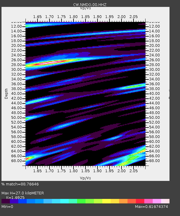
| Estimated Moho Depth: |
27.0 km |
| Estimated Crust Vp/Vs: |
1.69 |
| Assumed Crust Vp: |
5.066 km/s |
| Estimated Crust Vs: |
2.993 km/s |
| Estimated Crust Poisson's Ratio: |
0.23 |
|
| Radial Match: |
88.76646 % |
| Radial Bump: |
400 |
| Transverse Match: |
70.63081 % |
| Transverse Bump: |
400 |
| SOD ConfigId: |
25131211 |
| Insert Time: |
2021-08-28 12:04:20.399 +0000 |
| GWidth: |
2.5 |
| Max Bumps: |
400 |
| Tol: |
0.001 |
|
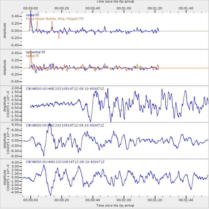
Signal To Noise
| Channel | StoN | STA | LTA |
| CW:NMDO:00:HHZ:20210814T12:08:19.409971Z | 12.249337 | 1.7935298E-6 | 1.4641851E-7 |
| CW:NMDO:00:HHN:20210814T12:08:19.409971Z | 3.2579918 | 7.5548854E-7 | 2.318878E-7 |
| CW:NMDO:00:HHE:20210814T12:08:19.409971Z | 2.6055663 | 4.4619415E-7 | 1.7124651E-7 |
| Arrivals |
| Ps | 3.8 SECOND |
| PpPs | 14 SECOND |
| PsPs/PpSs | 18 SECOND |


