You are here: Home > Network List > EC - Ecuador Seismic Network Stations List
> Station SLOR TEMP - COTO > Earthquake Result Viewer
SLOR TEMP - COTO - Earthquake Result Viewer
| Earthquake location: |
Alaska Peninsula |
| Earthquake latitude/longitude: |
55.2/-157.7 |
| Earthquake time(UTC): |
2021/08/14 (226) 11:57:42 GMT |
| Earthquake Depth: |
4.8 km |
| Earthquake Magnitude: |
6.4 ml |
| Earthquake Catalog/Contributor: |
NEIC PDE/ak |
|
| Network: |
EC Ecuador Seismic Network |
| Station: |
SLOR TEMP - COTO |
| Lat/Lon: |
0.73 S/78.50 W |
| Elevation: |
3600 m |
|
| Distance: |
84.4 deg |
| Az: |
99.291 deg |
| Baz: |
325.576 deg |
| Ray Param: |
0.045492534 |
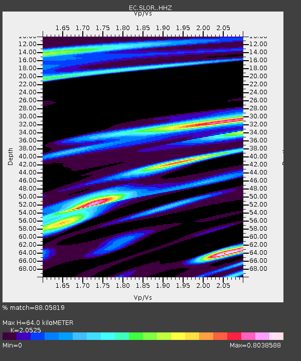
| Estimated Moho Depth: |
64.0 km |
| Estimated Crust Vp/Vs: |
2.05 |
| Assumed Crust Vp: |
6.472 km/s |
| Estimated Crust Vs: |
3.153 km/s |
| Estimated Crust Poisson's Ratio: |
0.34 |
|
| Radial Match: |
88.05819 % |
| Radial Bump: |
400 |
| Transverse Match: |
81.51288 % |
| Transverse Bump: |
400 |
| SOD ConfigId: |
25131211 |
| Insert Time: |
2021-08-28 12:04:52.164 +0000 |
| GWidth: |
2.5 |
| Max Bumps: |
400 |
| Tol: |
0.001 |
|

Signal To Noise
| Channel | StoN | STA | LTA |
| EC:SLOR: :HHZ:20210814T12:09:44.749998Z | 5.913504 | 3.7315684E-7 | 6.310249E-8 |
| EC:SLOR: :HHN:20210814T12:09:44.749998Z | 1.7442447 | 1.4583364E-7 | 8.360847E-8 |
| EC:SLOR: :HHE:20210814T12:09:44.749998Z | 1.343216 | 9.984666E-8 | 7.433403E-8 |
| Arrivals |
| Ps | 11 SECOND |
| PpPs | 30 SECOND |
| PsPs/PpSs | 40 SECOND |


