You are here: Home > Network List > GB - Great Britain Seismograph Network Stations List
> Station EDMD EDMUNDBYERS, ENGLAND > Earthquake Result Viewer
EDMD EDMUNDBYERS, ENGLAND - Earthquake Result Viewer
| Earthquake location: |
Alaska Peninsula |
| Earthquake latitude/longitude: |
55.2/-157.7 |
| Earthquake time(UTC): |
2021/08/14 (226) 11:57:42 GMT |
| Earthquake Depth: |
4.8 km |
| Earthquake Magnitude: |
6.4 ml |
| Earthquake Catalog/Contributor: |
NEIC PDE/ak |
|
| Network: |
GB Great Britain Seismograph Network |
| Station: |
EDMD EDMUNDBYERS, ENGLAND |
| Lat/Lon: |
54.83 N/1.96 W |
| Elevation: |
337 m |
|
| Distance: |
68.5 deg |
| Az: |
14.801 deg |
| Baz: |
345.351 deg |
| Ray Param: |
0.056269586 |
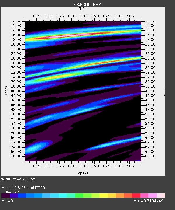
| Estimated Moho Depth: |
16.25 km |
| Estimated Crust Vp/Vs: |
1.77 |
| Assumed Crust Vp: |
6.24 km/s |
| Estimated Crust Vs: |
3.525 km/s |
| Estimated Crust Poisson's Ratio: |
0.27 |
|
| Radial Match: |
97.19551 % |
| Radial Bump: |
344 |
| Transverse Match: |
72.17241 % |
| Transverse Bump: |
400 |
| SOD ConfigId: |
25131211 |
| Insert Time: |
2021-08-28 12:05:33.855 +0000 |
| GWidth: |
2.5 |
| Max Bumps: |
400 |
| Tol: |
0.001 |
|

Signal To Noise
| Channel | StoN | STA | LTA |
| GB:EDMD: :HHZ:20210814T12:08:14.720029Z | 37.592667 | 1.0299833E-5 | 2.7398514E-7 |
| GB:EDMD: :HHN:20210814T12:08:14.720029Z | 21.785234 | 4.5580236E-6 | 2.0922536E-7 |
| GB:EDMD: :HHE:20210814T12:08:14.720029Z | 7.485126 | 1.3858422E-6 | 1.8514615E-7 |
| Arrivals |
| Ps | 2.1 SECOND |
| PpPs | 7.0 SECOND |
| PsPs/PpSs | 9.0 SECOND |


