You are here: Home > Network List > GB - Great Britain Seismograph Network Stations List
> Station INVG INVERGELDIE , ENGLAND > Earthquake Result Viewer
INVG INVERGELDIE , ENGLAND - Earthquake Result Viewer
| Earthquake location: |
Alaska Peninsula |
| Earthquake latitude/longitude: |
55.2/-157.7 |
| Earthquake time(UTC): |
2021/08/14 (226) 11:57:42 GMT |
| Earthquake Depth: |
4.8 km |
| Earthquake Magnitude: |
6.4 ml |
| Earthquake Catalog/Contributor: |
NEIC PDE/ak |
|
| Network: |
GB Great Britain Seismograph Network |
| Station: |
INVG INVERGELDIE , ENGLAND |
| Lat/Lon: |
56.43 N/4.04 W |
| Elevation: |
279 m |
|
| Distance: |
66.6 deg |
| Az: |
15.573 deg |
| Baz: |
343.932 deg |
| Ray Param: |
0.05749188 |
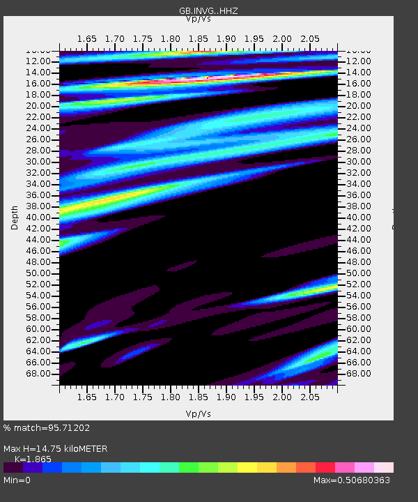
| Estimated Moho Depth: |
14.75 km |
| Estimated Crust Vp/Vs: |
1.87 |
| Assumed Crust Vp: |
6.276 km/s |
| Estimated Crust Vs: |
3.365 km/s |
| Estimated Crust Poisson's Ratio: |
0.30 |
|
| Radial Match: |
95.71202 % |
| Radial Bump: |
283 |
| Transverse Match: |
68.24645 % |
| Transverse Bump: |
400 |
| SOD ConfigId: |
25131211 |
| Insert Time: |
2021-08-28 12:05:45.374 +0000 |
| GWidth: |
2.5 |
| Max Bumps: |
400 |
| Tol: |
0.001 |
|

Signal To Noise
| Channel | StoN | STA | LTA |
| GB:INVG: :HHZ:20210814T12:08:03.030027Z | 39.415806 | 4.5185498E-6 | 1.1463801E-7 |
| GB:INVG: :HHN:20210814T12:08:03.030027Z | 27.77029 | 1.9980766E-6 | 7.195016E-8 |
| GB:INVG: :HHE:20210814T12:08:03.030027Z | 6.0124183 | 5.176754E-7 | 8.610103E-8 |
| Arrivals |
| Ps | 2.1 SECOND |
| PpPs | 6.5 SECOND |
| PsPs/PpSs | 8.6 SECOND |


