You are here: Home > Network List > GM - US Geological Survey Networks Stations List
> Station NMP02 New Mexico Permian - Site# 02 > Earthquake Result Viewer
NMP02 New Mexico Permian - Site# 02 - Earthquake Result Viewer
| Earthquake location: |
Alaska Peninsula |
| Earthquake latitude/longitude: |
55.2/-157.7 |
| Earthquake time(UTC): |
2021/08/14 (226) 11:57:42 GMT |
| Earthquake Depth: |
4.8 km |
| Earthquake Magnitude: |
6.4 ml |
| Earthquake Catalog/Contributor: |
NEIC PDE/ak |
|
| Network: |
GM US Geological Survey Networks |
| Station: |
NMP02 New Mexico Permian - Site# 02 |
| Lat/Lon: |
32.09 N/103.86 W |
| Elevation: |
996 m |
|
| Distance: |
43.9 deg |
| Az: |
98.928 deg |
| Baz: |
318.194 deg |
| Ray Param: |
0.0722478 |
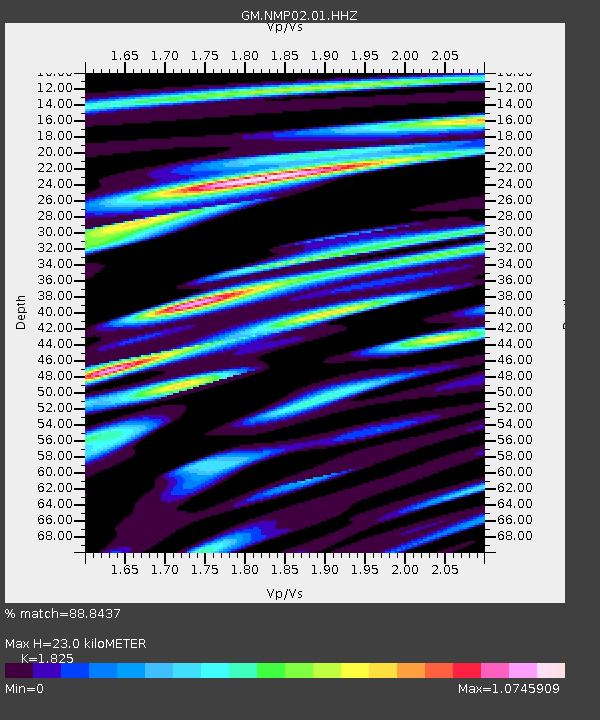
| Estimated Moho Depth: |
23.0 km |
| Estimated Crust Vp/Vs: |
1.83 |
| Assumed Crust Vp: |
6.129 km/s |
| Estimated Crust Vs: |
3.358 km/s |
| Estimated Crust Poisson's Ratio: |
0.29 |
|
| Radial Match: |
88.8437 % |
| Radial Bump: |
400 |
| Transverse Match: |
68.13164 % |
| Transverse Bump: |
400 |
| SOD ConfigId: |
25131211 |
| Insert Time: |
2021-08-28 12:06:22.946 +0000 |
| GWidth: |
2.5 |
| Max Bumps: |
400 |
| Tol: |
0.001 |
|

Signal To Noise
| Channel | StoN | STA | LTA |
| GM:NMP02:01:HHZ:20210814T12:05:19.515012Z | 16.825718 | 3.6647782E-6 | 2.1780814E-7 |
| GM:NMP02:01:HHN:20210814T12:05:19.515012Z | 7.5786037 | 1.5343364E-6 | 2.0245635E-7 |
| GM:NMP02:01:HHE:20210814T12:05:19.515012Z | 4.498722 | 1.384426E-6 | 3.0773762E-7 |
| Arrivals |
| Ps | 3.3 SECOND |
| PpPs | 10 SECOND |
| PsPs/PpSs | 13 SECOND |


