You are here: Home > Network List > GM - US Geological Survey Networks Stations List
> Station NMP11 New Mexico Permian - Site# W1S1 > Earthquake Result Viewer
NMP11 New Mexico Permian - Site# W1S1 - Earthquake Result Viewer
| Earthquake location: |
Alaska Peninsula |
| Earthquake latitude/longitude: |
55.2/-157.7 |
| Earthquake time(UTC): |
2021/08/14 (226) 11:57:42 GMT |
| Earthquake Depth: |
4.8 km |
| Earthquake Magnitude: |
6.4 ml |
| Earthquake Catalog/Contributor: |
NEIC PDE/ak |
|
| Network: |
GM US Geological Survey Networks |
| Station: |
NMP11 New Mexico Permian - Site# W1S1 |
| Lat/Lon: |
32.01 N/103.93 W |
| Elevation: |
883 m |
|
| Distance: |
44.0 deg |
| Az: |
99.072 deg |
| Baz: |
318.26 deg |
| Ray Param: |
0.07223322 |
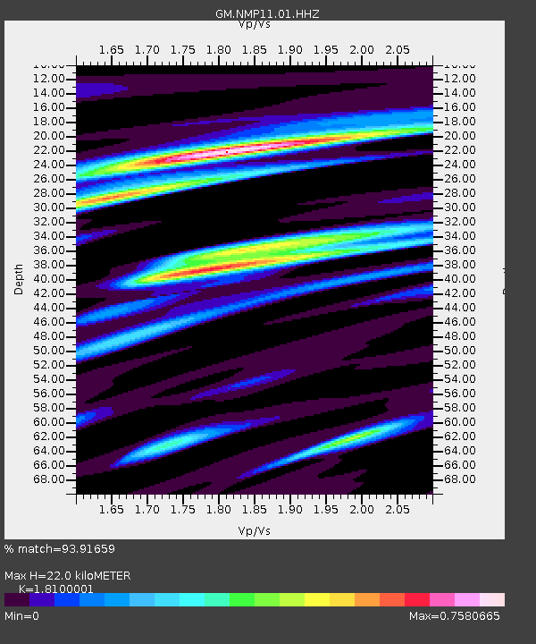
| Estimated Moho Depth: |
22.0 km |
| Estimated Crust Vp/Vs: |
1.81 |
| Assumed Crust Vp: |
6.129 km/s |
| Estimated Crust Vs: |
3.386 km/s |
| Estimated Crust Poisson's Ratio: |
0.28 |
|
| Radial Match: |
93.91659 % |
| Radial Bump: |
400 |
| Transverse Match: |
78.73749 % |
| Transverse Bump: |
375 |
| SOD ConfigId: |
25131211 |
| Insert Time: |
2021-08-28 12:06:23.231 +0000 |
| GWidth: |
2.5 |
| Max Bumps: |
400 |
| Tol: |
0.001 |
|

Signal To Noise
| Channel | StoN | STA | LTA |
| GM:NMP11:01:HHZ:20210814T12:05:19.690Z | 23.691198 | 3.4528673E-6 | 1.4574472E-7 |
| GM:NMP11:01:HHN:20210814T12:05:19.690Z | 8.297036 | 1.2965676E-6 | 1.5626877E-7 |
| GM:NMP11:01:HHE:20210814T12:05:19.690Z | 9.745971 | 1.0353242E-6 | 1.0623099E-7 |
| Arrivals |
| Ps | 3.1 SECOND |
| PpPs | 9.5 SECOND |
| PsPs/PpSs | 13 SECOND |


