You are here: Home > Network List > GM - US Geological Survey Networks Stations List
> Station NMP53 New Mexico Permian - Site# W5S3 > Earthquake Result Viewer
NMP53 New Mexico Permian - Site# W5S3 - Earthquake Result Viewer
| Earthquake location: |
Alaska Peninsula |
| Earthquake latitude/longitude: |
55.2/-157.7 |
| Earthquake time(UTC): |
2021/08/14 (226) 11:57:42 GMT |
| Earthquake Depth: |
4.8 km |
| Earthquake Magnitude: |
6.4 ml |
| Earthquake Catalog/Contributor: |
NEIC PDE/ak |
|
| Network: |
GM US Geological Survey Networks |
| Station: |
NMP53 New Mexico Permian - Site# W5S3 |
| Lat/Lon: |
32.18 N/103.43 W |
| Elevation: |
1037 m |
|
| Distance: |
44.1 deg |
| Az: |
98.454 deg |
| Baz: |
318.08 deg |
| Ray Param: |
0.07214553 |
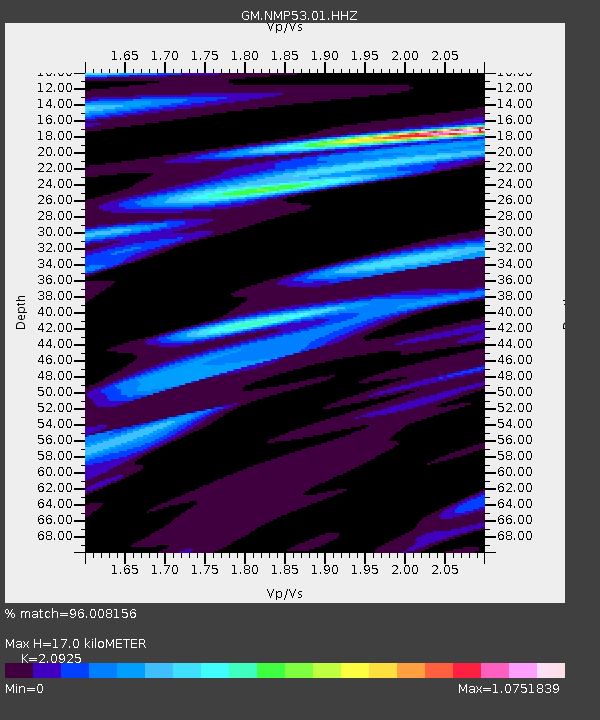
| Estimated Moho Depth: |
17.0 km |
| Estimated Crust Vp/Vs: |
2.09 |
| Assumed Crust Vp: |
6.129 km/s |
| Estimated Crust Vs: |
2.929 km/s |
| Estimated Crust Poisson's Ratio: |
0.35 |
|
| Radial Match: |
96.008156 % |
| Radial Bump: |
347 |
| Transverse Match: |
69.69254 % |
| Transverse Bump: |
400 |
| SOD ConfigId: |
25131211 |
| Insert Time: |
2021-08-28 12:06:37.992 +0000 |
| GWidth: |
2.5 |
| Max Bumps: |
400 |
| Tol: |
0.001 |
|

Signal To Noise
| Channel | StoN | STA | LTA |
| GM:NMP53:01:HHZ:20210814T12:05:20.95001Z | 21.540806 | 3.278326E-6 | 1.5219143E-7 |
| GM:NMP53:01:HHN:20210814T12:05:20.95001Z | 10.557548 | 1.2055771E-6 | 1.1419102E-7 |
| GM:NMP53:01:HHE:20210814T12:05:20.95001Z | 5.151308 | 1.0641912E-6 | 2.0658658E-7 |
| Arrivals |
| Ps | 3.2 SECOND |
| PpPs | 8.2 SECOND |
| PsPs/PpSs | 11 SECOND |


