You are here: Home > Network List > GM - US Geological Survey Networks Stations List
> Station NMP23 New Mexico Permian - Site# W2S3 > Earthquake Result Viewer
NMP23 New Mexico Permian - Site# W2S3 - Earthquake Result Viewer
| Earthquake location: |
Alaska Peninsula |
| Earthquake latitude/longitude: |
55.2/-157.7 |
| Earthquake time(UTC): |
2021/08/14 (226) 11:57:42 GMT |
| Earthquake Depth: |
4.8 km |
| Earthquake Magnitude: |
6.4 ml |
| Earthquake Catalog/Contributor: |
NEIC PDE/ak |
|
| Network: |
GM US Geological Survey Networks |
| Station: |
NMP23 New Mexico Permian - Site# W2S3 |
| Lat/Lon: |
32.17 N/103.80 W |
| Elevation: |
1050 m |
|
| Distance: |
43.9 deg |
| Az: |
98.801 deg |
| Baz: |
318.133 deg |
| Ray Param: |
0.07226418 |
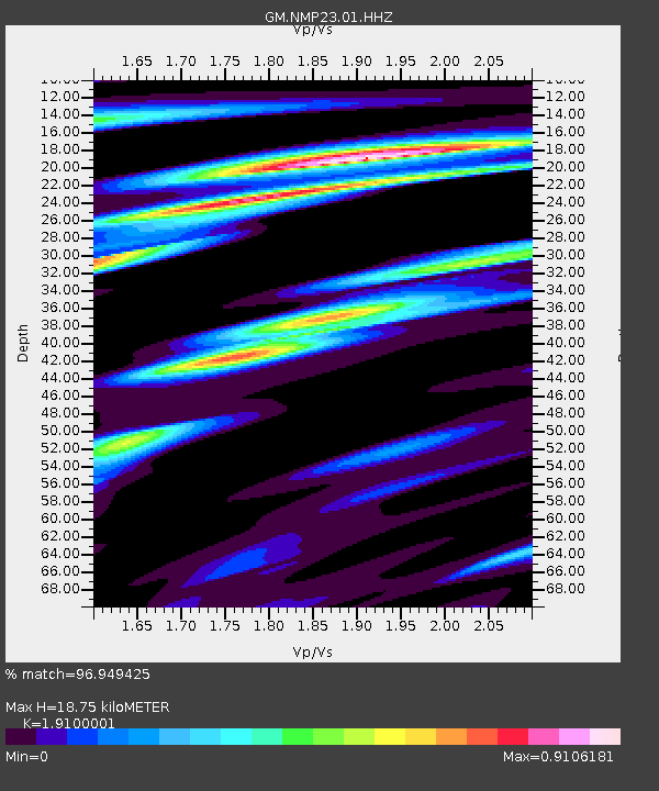
| Estimated Moho Depth: |
18.75 km |
| Estimated Crust Vp/Vs: |
1.91 |
| Assumed Crust Vp: |
6.129 km/s |
| Estimated Crust Vs: |
3.209 km/s |
| Estimated Crust Poisson's Ratio: |
0.31 |
|
| Radial Match: |
96.949425 % |
| Radial Bump: |
383 |
| Transverse Match: |
80.37627 % |
| Transverse Bump: |
400 |
| SOD ConfigId: |
25131211 |
| Insert Time: |
2021-08-28 12:06:38.742 +0000 |
| GWidth: |
2.5 |
| Max Bumps: |
400 |
| Tol: |
0.001 |
|

Signal To Noise
| Channel | StoN | STA | LTA |
| GM:NMP23:01:HHZ:20210814T12:05:19.315Z | 19.381407 | 3.5321457E-6 | 1.8224402E-7 |
| GM:NMP23:01:HHN:20210814T12:05:19.315Z | 8.073364 | 1.4376822E-6 | 1.7807719E-7 |
| GM:NMP23:01:HHE:20210814T12:05:19.315Z | 6.804724 | 1.1108489E-6 | 1.6324671E-7 |
| Arrivals |
| Ps | 2.9 SECOND |
| PpPs | 8.4 SECOND |
| PsPs/PpSs | 11 SECOND |


