You are here: Home > Network List > GS - US Geological Survey Networks Stations List
> Station DEC06 Boomer > Earthquake Result Viewer
DEC06 Boomer - Earthquake Result Viewer
| Earthquake location: |
Alaska Peninsula |
| Earthquake latitude/longitude: |
55.2/-157.7 |
| Earthquake time(UTC): |
2021/08/14 (226) 11:57:42 GMT |
| Earthquake Depth: |
4.8 km |
| Earthquake Magnitude: |
6.4 ml |
| Earthquake Catalog/Contributor: |
NEIC PDE/ak |
|
| Network: |
GS US Geological Survey Networks |
| Station: |
DEC06 Boomer |
| Lat/Lon: |
39.90 N/88.95 W |
| Elevation: |
215 m |
|
| Distance: |
46.9 deg |
| Az: |
79.147 deg |
| Baz: |
313.012 deg |
| Ray Param: |
0.07037148 |
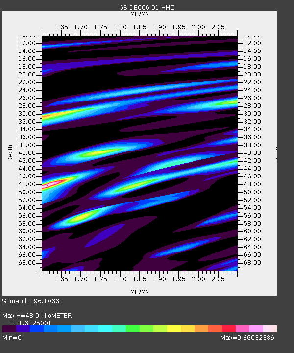
| Estimated Moho Depth: |
48.0 km |
| Estimated Crust Vp/Vs: |
1.61 |
| Assumed Crust Vp: |
6.444 km/s |
| Estimated Crust Vs: |
3.996 km/s |
| Estimated Crust Poisson's Ratio: |
0.19 |
|
| Radial Match: |
96.10661 % |
| Radial Bump: |
210 |
| Transverse Match: |
82.80806 % |
| Transverse Bump: |
400 |
| SOD ConfigId: |
25131211 |
| Insert Time: |
2021-08-28 12:06:57.543 +0000 |
| GWidth: |
2.5 |
| Max Bumps: |
400 |
| Tol: |
0.001 |
|

Signal To Noise
| Channel | StoN | STA | LTA |
| GS:DEC06:01:HHZ:20210814T12:05:43.005002Z | 12.448343 | 2.6737805E-6 | 2.1479006E-7 |
| GS:DEC06:01:HHN:20210814T12:05:43.005002Z | 3.8329632 | 1.1070254E-6 | 2.888171E-7 |
| GS:DEC06:01:HHE:20210814T12:05:43.005002Z | 3.8208754 | 1.1764292E-6 | 3.0789522E-7 |
| Arrivals |
| Ps | 4.9 SECOND |
| PpPs | 18 SECOND |
| PsPs/PpSs | 23 SECOND |


