You are here: Home > Network List > GS - US Geological Survey Networks Stations List
> Station PR05 PR05, Yauco > Earthquake Result Viewer
PR05 PR05, Yauco - Earthquake Result Viewer
| Earthquake location: |
Alaska Peninsula |
| Earthquake latitude/longitude: |
55.2/-157.7 |
| Earthquake time(UTC): |
2021/08/14 (226) 11:57:42 GMT |
| Earthquake Depth: |
4.8 km |
| Earthquake Magnitude: |
6.4 ml |
| Earthquake Catalog/Contributor: |
NEIC PDE/ak |
|
| Network: |
GS US Geological Survey Networks |
| Station: |
PR05 PR05, Yauco |
| Lat/Lon: |
18.05 N/66.86 W |
| Elevation: |
73 m |
|
| Distance: |
75.9 deg |
| Az: |
78.828 deg |
| Baz: |
323.799 deg |
| Ray Param: |
0.051402576 |
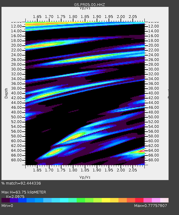
| Estimated Moho Depth: |
63.75 km |
| Estimated Crust Vp/Vs: |
2.10 |
| Assumed Crust Vp: |
5.14 km/s |
| Estimated Crust Vs: |
2.451 km/s |
| Estimated Crust Poisson's Ratio: |
0.35 |
|
| Radial Match: |
92.444336 % |
| Radial Bump: |
400 |
| Transverse Match: |
93.450226 % |
| Transverse Bump: |
400 |
| SOD ConfigId: |
25131211 |
| Insert Time: |
2021-08-28 12:07:12.369 +0000 |
| GWidth: |
2.5 |
| Max Bumps: |
400 |
| Tol: |
0.001 |
|

Signal To Noise
| Channel | StoN | STA | LTA |
| GS:PR05:00:HHZ:20210814T12:08:58.604001Z | 14.880789 | 3.6883944E-6 | 2.4786283E-7 |
| GS:PR05:00:HH1:20210814T12:08:58.604001Z | 4.657106 | 1.3265503E-6 | 2.8484436E-7 |
| GS:PR05:00:HH2:20210814T12:08:58.604001Z | 2.5691428 | 7.6038543E-7 | 2.9596853E-7 |
| Arrivals |
| Ps | 14 SECOND |
| PpPs | 38 SECOND |
| PsPs/PpSs | 52 SECOND |


