You are here: Home > Network List > GS - US Geological Survey Networks Stations List
> Station VEA2 VEA1 > Earthquake Result Viewer
VEA2 VEA1 - Earthquake Result Viewer
| Earthquake location: |
Alaska Peninsula |
| Earthquake latitude/longitude: |
55.2/-157.7 |
| Earthquake time(UTC): |
2021/08/14 (226) 11:57:42 GMT |
| Earthquake Depth: |
4.8 km |
| Earthquake Magnitude: |
6.4 ml |
| Earthquake Catalog/Contributor: |
NEIC PDE/ak |
|
| Network: |
GS US Geological Survey Networks |
| Station: |
VEA2 VEA1 |
| Lat/Lon: |
34.94 N/106.46 W |
| Elevation: |
1844 m |
|
| Distance: |
40.4 deg |
| Az: |
98.429 deg |
| Baz: |
316.394 deg |
| Ray Param: |
0.0744579 |
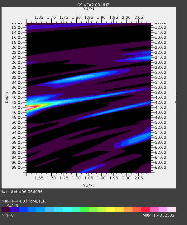
| Estimated Moho Depth: |
44.0 km |
| Estimated Crust Vp/Vs: |
1.60 |
| Assumed Crust Vp: |
6.502 km/s |
| Estimated Crust Vs: |
4.063 km/s |
| Estimated Crust Poisson's Ratio: |
0.18 |
|
| Radial Match: |
96.066956 % |
| Radial Bump: |
297 |
| Transverse Match: |
87.55296 % |
| Transverse Bump: |
400 |
| SOD ConfigId: |
25131211 |
| Insert Time: |
2021-08-28 12:07:15.546 +0000 |
| GWidth: |
2.5 |
| Max Bumps: |
400 |
| Tol: |
0.001 |
|

Signal To Noise
| Channel | StoN | STA | LTA |
| GS:VEA2:00:HHZ:20210814T12:04:50.479001Z | 38.19828 | 2.8189181E-6 | 7.379699E-8 |
| GS:VEA2:00:HH1:20210814T12:04:50.479001Z | 32.414303 | 1.4957328E-6 | 4.6144223E-8 |
| GS:VEA2:00:HH2:20210814T12:04:50.479001Z | 19.924128 | 1.0880005E-6 | 5.4607185E-8 |
| Arrivals |
| Ps | 4.4 SECOND |
| PpPs | 16 SECOND |
| PsPs/PpSs | 21 SECOND |


