You are here: Home > Network List > HV - Hawaiian Volcano Observatory Network Stations List
> Station MOKD Mokuaweoweo, Hawaii Digital > Earthquake Result Viewer
MOKD Mokuaweoweo, Hawaii Digital - Earthquake Result Viewer
| Earthquake location: |
Alaska Peninsula |
| Earthquake latitude/longitude: |
55.2/-157.7 |
| Earthquake time(UTC): |
2021/08/14 (226) 11:57:42 GMT |
| Earthquake Depth: |
4.8 km |
| Earthquake Magnitude: |
6.4 ml |
| Earthquake Catalog/Contributor: |
NEIC PDE/ak |
|
| Network: |
HV Hawaiian Volcano Observatory Network |
| Station: |
MOKD Mokuaweoweo, Hawaii Digital |
| Lat/Lon: |
19.49 N/155.60 W |
| Elevation: |
4102 m |
|
| Distance: |
35.7 deg |
| Az: |
176.59 deg |
| Baz: |
357.931 deg |
| Ray Param: |
0.07708101 |
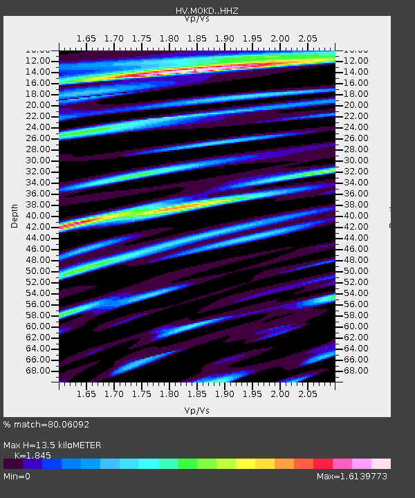
| Estimated Moho Depth: |
13.5 km |
| Estimated Crust Vp/Vs: |
1.85 |
| Assumed Crust Vp: |
5.195 km/s |
| Estimated Crust Vs: |
2.816 km/s |
| Estimated Crust Poisson's Ratio: |
0.29 |
|
| Radial Match: |
80.06092 % |
| Radial Bump: |
400 |
| Transverse Match: |
64.075294 % |
| Transverse Bump: |
400 |
| SOD ConfigId: |
25131211 |
| Insert Time: |
2021-08-28 12:07:48.925 +0000 |
| GWidth: |
2.5 |
| Max Bumps: |
400 |
| Tol: |
0.001 |
|

Signal To Noise
| Channel | StoN | STA | LTA |
| HV:MOKD: :HHZ:20210814T12:04:11.429014Z | 8.937411 | 7.4827944E-6 | 8.372441E-7 |
| HV:MOKD: :HHN:20210814T12:04:11.429014Z | 3.4786255 | 7.1599948E-6 | 2.0582827E-6 |
| HV:MOKD: :HHE:20210814T12:04:11.429014Z | 0.6794374 | 2.1998194E-6 | 3.2377072E-6 |
| Arrivals |
| Ps | 2.3 SECOND |
| PpPs | 7.1 SECOND |
| PsPs/PpSs | 9.4 SECOND |


