You are here: Home > Network List > IU - Global Seismograph Network (GSN - IRIS/USGS) Stations List
> Station ULN Ulaanbaatar, Mongolia > Earthquake Result Viewer
ULN Ulaanbaatar, Mongolia - Earthquake Result Viewer
| Earthquake location: |
Alaska Peninsula |
| Earthquake latitude/longitude: |
55.2/-157.7 |
| Earthquake time(UTC): |
2021/08/14 (226) 11:57:42 GMT |
| Earthquake Depth: |
4.8 km |
| Earthquake Magnitude: |
6.4 ml |
| Earthquake Catalog/Contributor: |
NEIC PDE/ak |
|
| Network: |
IU Global Seismograph Network (GSN - IRIS/USGS) |
| Station: |
ULN Ulaanbaatar, Mongolia |
| Lat/Lon: |
47.87 N/107.05 E |
| Elevation: |
1610 m |
|
| Distance: |
55.2 deg |
| Az: |
305.249 deg |
| Baz: |
44.001 deg |
| Ray Param: |
0.06497031 |
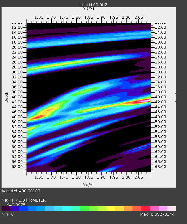
| Estimated Moho Depth: |
41.0 km |
| Estimated Crust Vp/Vs: |
2.10 |
| Assumed Crust Vp: |
6.642 km/s |
| Estimated Crust Vs: |
3.167 km/s |
| Estimated Crust Poisson's Ratio: |
0.35 |
|
| Radial Match: |
98.38188 % |
| Radial Bump: |
338 |
| Transverse Match: |
88.29309 % |
| Transverse Bump: |
400 |
| SOD ConfigId: |
25131211 |
| Insert Time: |
2021-08-28 12:09:13.846 +0000 |
| GWidth: |
2.5 |
| Max Bumps: |
400 |
| Tol: |
0.001 |
|

Signal To Noise
| Channel | StoN | STA | LTA |
| IU:ULN:00:BHZ:20210814T12:06:45.319028Z | 124.52887 | 9.7087095E-6 | 7.796353E-8 |
| IU:ULN:00:BH1:20210814T12:06:45.319028Z | 58.842854 | 3.14614E-6 | 5.3466817E-8 |
| IU:ULN:00:BH2:20210814T12:06:45.319028Z | 57.95765 | 3.3392917E-6 | 5.7616063E-8 |
| Arrivals |
| Ps | 7.1 SECOND |
| PpPs | 18 SECOND |
| PsPs/PpSs | 25 SECOND |


