You are here: Home > Network List > N4 - Central and EAstern US Network Stations List
> Station L56A Greenwood, NY, USA > Earthquake Result Viewer
L56A Greenwood, NY, USA - Earthquake Result Viewer
| Earthquake location: |
Alaska Peninsula |
| Earthquake latitude/longitude: |
55.2/-157.7 |
| Earthquake time(UTC): |
2021/08/14 (226) 11:57:42 GMT |
| Earthquake Depth: |
4.8 km |
| Earthquake Magnitude: |
6.4 ml |
| Earthquake Catalog/Contributor: |
NEIC PDE/ak |
|
| Network: |
N4 Central and EAstern US Network |
| Station: |
L56A Greenwood, NY, USA |
| Lat/Lon: |
42.14 N/77.56 W |
| Elevation: |
688 m |
|
| Distance: |
51.6 deg |
| Az: |
69.189 deg |
| Baz: |
313.959 deg |
| Ray Param: |
0.067309946 |
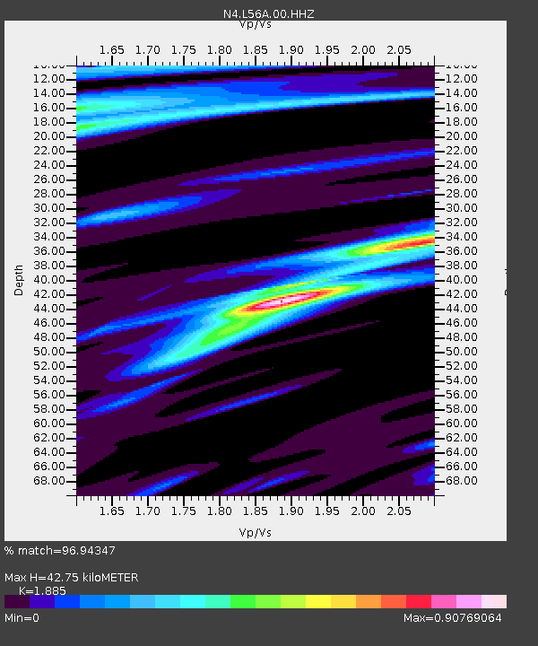
| Estimated Moho Depth: |
42.75 km |
| Estimated Crust Vp/Vs: |
1.88 |
| Assumed Crust Vp: |
6.476 km/s |
| Estimated Crust Vs: |
3.435 km/s |
| Estimated Crust Poisson's Ratio: |
0.30 |
|
| Radial Match: |
96.94347 % |
| Radial Bump: |
330 |
| Transverse Match: |
76.756645 % |
| Transverse Bump: |
400 |
| SOD ConfigId: |
25131211 |
| Insert Time: |
2021-08-28 12:12:34.191 +0000 |
| GWidth: |
2.5 |
| Max Bumps: |
400 |
| Tol: |
0.001 |
|

Signal To Noise
| Channel | StoN | STA | LTA |
| N4:L56A:00:HHZ:20210814T12:06:19.119993Z | 35.9376 | 5.2987803E-6 | 1.4744391E-7 |
| N4:L56A:00:HH1:20210814T12:06:19.119993Z | 18.55536 | 1.7913331E-6 | 9.653993E-8 |
| N4:L56A:00:HH2:20210814T12:06:19.119993Z | 20.549784 | 2.0597959E-6 | 1.0023443E-7 |
| Arrivals |
| Ps | 6.2 SECOND |
| PpPs | 18 SECOND |
| PsPs/PpSs | 24 SECOND |


