You are here: Home > Network List > N4 - Central and EAstern US Network Stations List
> Station L61B Northampton, MA, USA > Earthquake Result Viewer
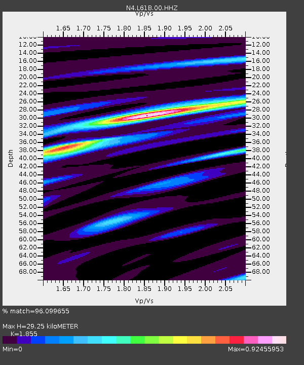
L61B Northampton, MA, USA - Earthquake Result Viewer
| Earthquake location: |
Alaska Peninsula |
| Earthquake latitude/longitude: |
55.2/-157.7 |
| Earthquake time(UTC): |
2021/08/14 (226) 11:57:42 GMT |
| Earthquake Depth: |
4.8 km |
| Earthquake Magnitude: |
6.4 ml |
| Earthquake Catalog/Contributor: |
NEIC PDE/ak |
|
| Network: |
N4 Central and EAstern US Network |
| Station: |
L61B Northampton, MA, USA |
| Lat/Lon: |
42.45 N/72.68 W |
| Elevation: |
261 m |
|
| Distance: |
54.0 deg |
| Az: |
65.722 deg |
| Baz: |
315.134 deg |
| Ray Param: |
0.06574788 |
| Estimated Moho Depth: |
29.25 km |
| Estimated Crust Vp/Vs: |
1.86 |
| Assumed Crust Vp: |
6.419 km/s |
| Estimated Crust Vs: |
3.461 km/s |
| Estimated Crust Poisson's Ratio: |
0.30 |
|
| Radial Match: |
96.099655 % |
| Radial Bump: |
247 |
| Transverse Match: |
90.74133 % |
| Transverse Bump: |
400 |
| SOD ConfigId: |
25131211 |
| Insert Time: |
2021-08-28 12:12:36.637 +0000 |
| GWidth: |
2.5 |
| Max Bumps: |
400 |
| Tol: |
0.001 |
|

Signal To Noise
| Channel | StoN | STA | LTA |
| N4:L61B:00:HHZ:20210814T12:06:36.539976Z | 33.78981 | 4.7536378E-6 | 1.4068257E-7 |
| N4:L61B:00:HH1:20210814T12:06:36.539976Z | 22.736431 | 1.757825E-6 | 7.7313146E-8 |
| N4:L61B:00:HH2:20210814T12:06:36.539976Z | 18.103806 | 1.5352103E-6 | 8.480042E-8 |
| Arrivals |
| Ps | 4.1 SECOND |
| PpPs | 12 SECOND |
| PsPs/PpSs | 16 SECOND |


