You are here: Home > Network List > N4 - Central and EAstern US Network Stations List
> Station Q54A Coxs Mills, WV, USA > Earthquake Result Viewer
Q54A Coxs Mills, WV, USA - Earthquake Result Viewer
| Earthquake location: |
Alaska Peninsula |
| Earthquake latitude/longitude: |
55.2/-157.7 |
| Earthquake time(UTC): |
2021/08/14 (226) 11:57:42 GMT |
| Earthquake Depth: |
4.8 km |
| Earthquake Magnitude: |
6.4 ml |
| Earthquake Catalog/Contributor: |
NEIC PDE/ak |
|
| Network: |
N4 Central and EAstern US Network |
| Station: |
Q54A Coxs Mills, WV, USA |
| Lat/Lon: |
38.98 N/80.83 W |
| Elevation: |
254 m |
|
| Distance: |
52.1 deg |
| Az: |
74.27 deg |
| Baz: |
314.977 deg |
| Ray Param: |
0.067024656 |
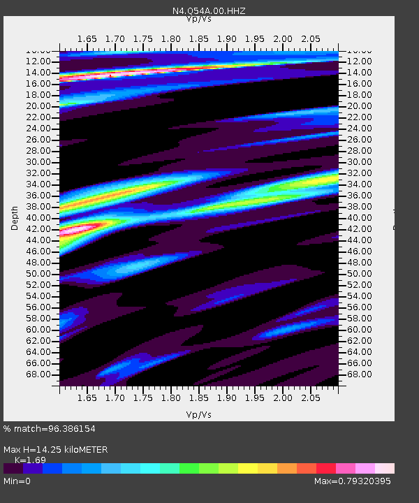
| Estimated Moho Depth: |
14.25 km |
| Estimated Crust Vp/Vs: |
1.69 |
| Assumed Crust Vp: |
6.207 km/s |
| Estimated Crust Vs: |
3.673 km/s |
| Estimated Crust Poisson's Ratio: |
0.23 |
|
| Radial Match: |
96.386154 % |
| Radial Bump: |
400 |
| Transverse Match: |
84.631386 % |
| Transverse Bump: |
400 |
| SOD ConfigId: |
25131211 |
| Insert Time: |
2021-08-28 12:13:16.957 +0000 |
| GWidth: |
2.5 |
| Max Bumps: |
400 |
| Tol: |
0.001 |
|

Signal To Noise
| Channel | StoN | STA | LTA |
| N4:Q54A:00:HHZ:20210814T12:06:22.289976Z | 28.061457 | 3.4723441E-6 | 1.2374069E-7 |
| N4:Q54A:00:HH1:20210814T12:06:22.289976Z | 12.978919 | 1.1791152E-6 | 9.0848495E-8 |
| N4:Q54A:00:HH2:20210814T12:06:22.289976Z | 8.4751625 | 1.2580882E-6 | 1.4844414E-7 |
| Arrivals |
| Ps | 1.7 SECOND |
| PpPs | 5.8 SECOND |
| PsPs/PpSs | 7.5 SECOND |


