You are here: Home > Network List > N4 - Central and EAstern US Network Stations List
> Station R49A Shelbyville, KY, USA > Earthquake Result Viewer
R49A Shelbyville, KY, USA - Earthquake Result Viewer
| Earthquake location: |
Alaska Peninsula |
| Earthquake latitude/longitude: |
55.2/-157.7 |
| Earthquake time(UTC): |
2021/08/14 (226) 11:57:42 GMT |
| Earthquake Depth: |
4.8 km |
| Earthquake Magnitude: |
6.4 ml |
| Earthquake Catalog/Contributor: |
NEIC PDE/ak |
|
| Network: |
N4 Central and EAstern US Network |
| Station: |
R49A Shelbyville, KY, USA |
| Lat/Lon: |
38.29 N/85.17 W |
| Elevation: |
251 m |
|
| Distance: |
50.1 deg |
| Az: |
77.976 deg |
| Baz: |
314.608 deg |
| Ray Param: |
0.06827852 |
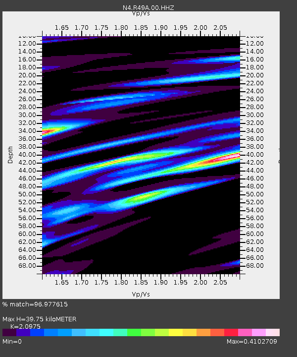
| Estimated Moho Depth: |
39.75 km |
| Estimated Crust Vp/Vs: |
2.10 |
| Assumed Crust Vp: |
6.498 km/s |
| Estimated Crust Vs: |
3.098 km/s |
| Estimated Crust Poisson's Ratio: |
0.35 |
|
| Radial Match: |
96.977615 % |
| Radial Bump: |
278 |
| Transverse Match: |
84.48859 % |
| Transverse Bump: |
400 |
| SOD ConfigId: |
25131211 |
| Insert Time: |
2021-08-28 12:13:19.918 +0000 |
| GWidth: |
2.5 |
| Max Bumps: |
400 |
| Tol: |
0.001 |
|

Signal To Noise
| Channel | StoN | STA | LTA |
| N4:R49A:00:HHZ:20210814T12:06:07.839994Z | 29.497707 | 2.8815198E-6 | 9.768623E-8 |
| N4:R49A:00:HH1:20210814T12:06:07.839994Z | 11.190371 | 1.0187684E-6 | 9.103974E-8 |
| N4:R49A:00:HH2:20210814T12:06:07.839994Z | 10.830479 | 9.598607E-7 | 8.862589E-8 |
| Arrivals |
| Ps | 7.1 SECOND |
| PpPs | 18 SECOND |
| PsPs/PpSs | 25 SECOND |


