You are here: Home > Network List > N4 - Central and EAstern US Network Stations List
> Station S54A Dingess, Beckley, WV, USA > Earthquake Result Viewer
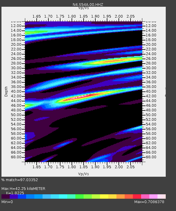
S54A Dingess, Beckley, WV, USA - Earthquake Result Viewer
| Earthquake location: |
Alaska Peninsula |
| Earthquake latitude/longitude: |
55.2/-157.7 |
| Earthquake time(UTC): |
2021/08/14 (226) 11:57:42 GMT |
| Earthquake Depth: |
4.8 km |
| Earthquake Magnitude: |
6.4 ml |
| Earthquake Catalog/Contributor: |
NEIC PDE/ak |
|
| Network: |
N4 Central and EAstern US Network |
| Station: |
S54A Dingess, Beckley, WV, USA |
| Lat/Lon: |
37.80 N/81.31 W |
| Elevation: |
636 m |
|
| Distance: |
52.6 deg |
| Az: |
75.658 deg |
| Baz: |
315.53 deg |
| Ray Param: |
0.06665075 |
| Estimated Moho Depth: |
42.25 km |
| Estimated Crust Vp/Vs: |
1.82 |
| Assumed Crust Vp: |
6.159 km/s |
| Estimated Crust Vs: |
3.379 km/s |
| Estimated Crust Poisson's Ratio: |
0.28 |
|
| Radial Match: |
97.03352 % |
| Radial Bump: |
275 |
| Transverse Match: |
84.709496 % |
| Transverse Bump: |
400 |
| SOD ConfigId: |
25131211 |
| Insert Time: |
2021-08-28 12:13:28.068 +0000 |
| GWidth: |
2.5 |
| Max Bumps: |
400 |
| Tol: |
0.001 |
|

Signal To Noise
| Channel | StoN | STA | LTA |
| N4:S54A:00:HHZ:20210814T12:06:26.549985Z | 25.216137 | 3.4525024E-6 | 1.3691638E-7 |
| N4:S54A:00:HH1:20210814T12:06:26.549985Z | 12.207135 | 1.3538738E-6 | 1.10908395E-7 |
| N4:S54A:00:HH2:20210814T12:06:26.549985Z | 10.091491 | 1.3261504E-6 | 1.3141272E-7 |
| Arrivals |
| Ps | 5.9 SECOND |
| PpPs | 18 SECOND |
| PsPs/PpSs | 24 SECOND |


