You are here: Home > Network List > N4 - Central and EAstern US Network Stations List
> Station V53A Sandy Mush, NC, USA > Earthquake Result Viewer
V53A Sandy Mush, NC, USA - Earthquake Result Viewer
| Earthquake location: |
Alaska Peninsula |
| Earthquake latitude/longitude: |
55.2/-157.7 |
| Earthquake time(UTC): |
2021/08/14 (226) 11:57:42 GMT |
| Earthquake Depth: |
4.8 km |
| Earthquake Magnitude: |
6.4 ml |
| Earthquake Catalog/Contributor: |
NEIC PDE/ak |
|
| Network: |
N4 Central and EAstern US Network |
| Station: |
V53A Sandy Mush, NC, USA |
| Lat/Lon: |
35.67 N/82.81 W |
| Elevation: |
681 m |
|
| Distance: |
53.3 deg |
| Az: |
78.595 deg |
| Baz: |
316.405 deg |
| Ray Param: |
0.06620862 |
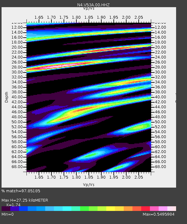
| Estimated Moho Depth: |
27.25 km |
| Estimated Crust Vp/Vs: |
1.74 |
| Assumed Crust Vp: |
6.35 km/s |
| Estimated Crust Vs: |
3.649 km/s |
| Estimated Crust Poisson's Ratio: |
0.25 |
|
| Radial Match: |
97.85185 % |
| Radial Bump: |
335 |
| Transverse Match: |
86.00364 % |
| Transverse Bump: |
400 |
| SOD ConfigId: |
25131211 |
| Insert Time: |
2021-08-28 12:13:48.199 +0000 |
| GWidth: |
2.5 |
| Max Bumps: |
400 |
| Tol: |
0.001 |
|

Signal To Noise
| Channel | StoN | STA | LTA |
| N4:V53A:00:HHZ:20210814T12:06:31.640012Z | 33.185577 | 2.537579E-6 | 7.6466314E-8 |
| N4:V53A:00:HH1:20210814T12:06:31.640012Z | 20.041138 | 8.7295246E-7 | 4.3558025E-8 |
| N4:V53A:00:HH2:20210814T12:06:31.640012Z | 10.669651 | 8.189304E-7 | 7.6753246E-8 |
| Arrivals |
| Ps | 3.4 SECOND |
| PpPs | 11 SECOND |
| PsPs/PpSs | 14 SECOND |


