You are here: Home > Network List > N4 - Central and EAstern US Network Stations List
> Station V55A Morning Dew, Taylorsville, NC, USA > Earthquake Result Viewer
V55A Morning Dew, Taylorsville, NC, USA - Earthquake Result Viewer
| Earthquake location: |
Alaska Peninsula |
| Earthquake latitude/longitude: |
55.2/-157.7 |
| Earthquake time(UTC): |
2021/08/14 (226) 11:57:42 GMT |
| Earthquake Depth: |
4.8 km |
| Earthquake Magnitude: |
6.4 ml |
| Earthquake Catalog/Contributor: |
NEIC PDE/ak |
|
| Network: |
N4 Central and EAstern US Network |
| Station: |
V55A Morning Dew, Taylorsville, NC, USA |
| Lat/Lon: |
35.85 N/81.21 W |
| Elevation: |
313 m |
|
| Distance: |
54.1 deg |
| Az: |
77.271 deg |
| Baz: |
316.55 deg |
| Ray Param: |
0.06568475 |
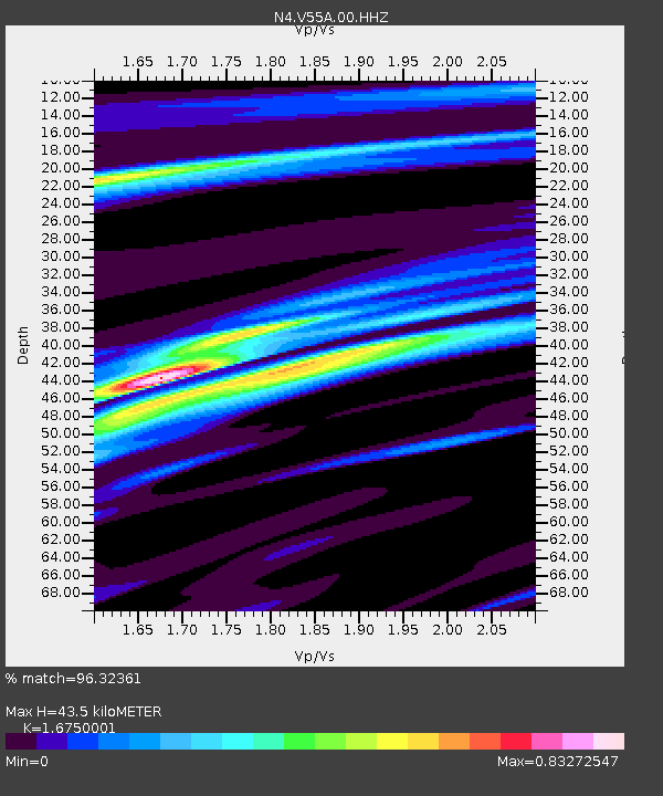
| Estimated Moho Depth: |
43.5 km |
| Estimated Crust Vp/Vs: |
1.68 |
| Assumed Crust Vp: |
6.419 km/s |
| Estimated Crust Vs: |
3.832 km/s |
| Estimated Crust Poisson's Ratio: |
0.22 |
|
| Radial Match: |
96.32361 % |
| Radial Bump: |
377 |
| Transverse Match: |
91.55538 % |
| Transverse Bump: |
400 |
| SOD ConfigId: |
25131211 |
| Insert Time: |
2021-08-28 12:13:48.637 +0000 |
| GWidth: |
2.5 |
| Max Bumps: |
400 |
| Tol: |
0.001 |
|

Signal To Noise
| Channel | StoN | STA | LTA |
| N4:V55A:00:HHZ:20210814T12:06:37.218992Z | 23.673735 | 2.4880135E-6 | 1.0509595E-7 |
| N4:V55A:00:HH1:20210814T12:06:37.218992Z | 11.609218 | 8.070174E-7 | 6.9515224E-8 |
| N4:V55A:00:HH2:20210814T12:06:37.218992Z | 7.3973484 | 8.5229897E-7 | 1.1521682E-7 |
| Arrivals |
| Ps | 4.8 SECOND |
| PpPs | 17 SECOND |
| PsPs/PpSs | 22 SECOND |


