You are here: Home > Network List > NM - Cooperative New Madrid Seismic Network Stations List
> Station CGM3 Cape Girardeau, MO > Earthquake Result Viewer
CGM3 Cape Girardeau, MO - Earthquake Result Viewer
| Earthquake location: |
Alaska Peninsula |
| Earthquake latitude/longitude: |
55.2/-157.7 |
| Earthquake time(UTC): |
2021/08/14 (226) 11:57:42 GMT |
| Earthquake Depth: |
4.8 km |
| Earthquake Magnitude: |
6.4 ml |
| Earthquake Catalog/Contributor: |
NEIC PDE/ak |
|
| Network: |
NM Cooperative New Madrid Seismic Network |
| Station: |
CGM3 Cape Girardeau, MO |
| Lat/Lon: |
37.30 N/89.66 W |
| Elevation: |
148 m |
|
| Distance: |
48.3 deg |
| Az: |
82.206 deg |
| Baz: |
314.633 deg |
| Ray Param: |
0.06947443 |
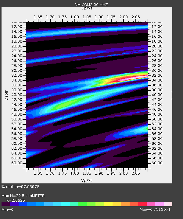
| Estimated Moho Depth: |
32.5 km |
| Estimated Crust Vp/Vs: |
2.06 |
| Assumed Crust Vp: |
6.444 km/s |
| Estimated Crust Vs: |
3.124 km/s |
| Estimated Crust Poisson's Ratio: |
0.35 |
|
| Radial Match: |
97.93978 % |
| Radial Bump: |
206 |
| Transverse Match: |
80.88233 % |
| Transverse Bump: |
400 |
| SOD ConfigId: |
25131211 |
| Insert Time: |
2021-08-28 12:14:24.662 +0000 |
| GWidth: |
2.5 |
| Max Bumps: |
400 |
| Tol: |
0.001 |
|

Signal To Noise
| Channel | StoN | STA | LTA |
| NM:CGM3:00:HHZ:20210814T12:05:53.830015Z | 18.451271 | 1.7650918E-6 | 9.5662344E-8 |
| NM:CGM3:00:HHN:20210814T12:05:53.830015Z | 12.507586 | 6.7877113E-7 | 5.4268757E-8 |
| NM:CGM3:00:HHE:20210814T12:05:53.830015Z | 8.63353 | 7.097537E-7 | 8.2208985E-8 |
| Arrivals |
| Ps | 5.6 SECOND |
| PpPs | 15 SECOND |
| PsPs/PpSs | 20 SECOND |


