You are here: Home > Network List > NM - Cooperative New Madrid Seismic Network Stations List
> Station UALR University of Arkansas, Little Rock > Earthquake Result Viewer
UALR University of Arkansas, Little Rock - Earthquake Result Viewer
| Earthquake location: |
Alaska Peninsula |
| Earthquake latitude/longitude: |
55.2/-157.7 |
| Earthquake time(UTC): |
2021/08/14 (226) 11:57:42 GMT |
| Earthquake Depth: |
4.8 km |
| Earthquake Magnitude: |
6.4 ml |
| Earthquake Catalog/Contributor: |
NEIC PDE/ak |
|
| Network: |
NM Cooperative New Madrid Seismic Network |
| Station: |
UALR University of Arkansas, Little Rock |
| Lat/Lon: |
34.78 N/92.34 W |
| Elevation: |
138 m |
|
| Distance: |
48.6 deg |
| Az: |
86.641 deg |
| Baz: |
316.004 deg |
| Ray Param: |
0.06930686 |
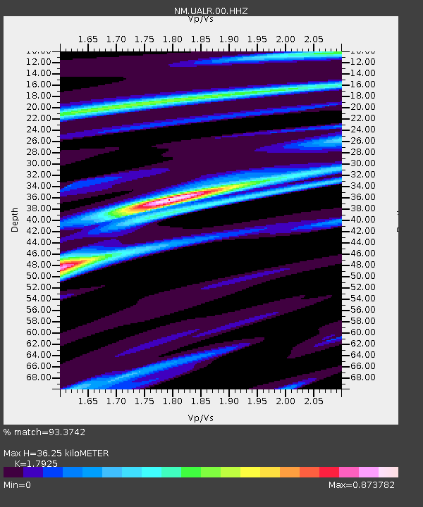
| Estimated Moho Depth: |
36.25 km |
| Estimated Crust Vp/Vs: |
1.79 |
| Assumed Crust Vp: |
6.498 km/s |
| Estimated Crust Vs: |
3.625 km/s |
| Estimated Crust Poisson's Ratio: |
0.27 |
|
| Radial Match: |
93.3742 % |
| Radial Bump: |
291 |
| Transverse Match: |
83.74584 % |
| Transverse Bump: |
400 |
| SOD ConfigId: |
25131211 |
| Insert Time: |
2021-08-28 12:14:55.448 +0000 |
| GWidth: |
2.5 |
| Max Bumps: |
400 |
| Tol: |
0.001 |
|

Signal To Noise
| Channel | StoN | STA | LTA |
| NM:UALR:00:HHZ:20210814T12:05:55.820005Z | 10.325962 | 1.1401828E-6 | 1.1041903E-7 |
| NM:UALR:00:HHN:20210814T12:05:55.820005Z | 3.0841796 | 3.3812188E-7 | 1.0963105E-7 |
| NM:UALR:00:HHE:20210814T12:05:55.820005Z | 2.9362328 | 3.8420907E-7 | 1.3085102E-7 |
| Arrivals |
| Ps | 4.7 SECOND |
| PpPs | 15 SECOND |
| PsPs/PpSs | 19 SECOND |


