You are here: Home > Network List > NM - Cooperative New Madrid Seismic Network Stations List
> Station X502 Temporary Arkansas > Earthquake Result Viewer
X502 Temporary Arkansas - Earthquake Result Viewer
| Earthquake location: |
Alaska Peninsula |
| Earthquake latitude/longitude: |
55.2/-157.7 |
| Earthquake time(UTC): |
2021/08/14 (226) 11:57:42 GMT |
| Earthquake Depth: |
4.8 km |
| Earthquake Magnitude: |
6.4 ml |
| Earthquake Catalog/Contributor: |
NEIC PDE/ak |
|
| Network: |
NM Cooperative New Madrid Seismic Network |
| Station: |
X502 Temporary Arkansas |
| Lat/Lon: |
35.49 N/92.39 W |
| Elevation: |
344 m |
|
| Distance: |
48.0 deg |
| Az: |
86.008 deg |
| Baz: |
315.558 deg |
| Ray Param: |
0.06965612 |
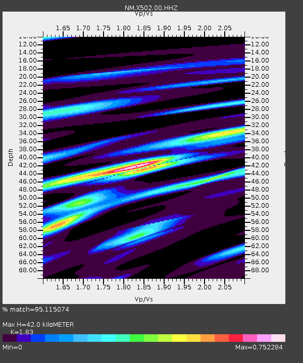
| Estimated Moho Depth: |
42.0 km |
| Estimated Crust Vp/Vs: |
1.83 |
| Assumed Crust Vp: |
6.498 km/s |
| Estimated Crust Vs: |
3.551 km/s |
| Estimated Crust Poisson's Ratio: |
0.29 |
|
| Radial Match: |
95.115074 % |
| Radial Bump: |
363 |
| Transverse Match: |
70.188416 % |
| Transverse Bump: |
400 |
| SOD ConfigId: |
25131211 |
| Insert Time: |
2021-08-28 12:15:00.524 +0000 |
| GWidth: |
2.5 |
| Max Bumps: |
400 |
| Tol: |
0.001 |
|

Signal To Noise
| Channel | StoN | STA | LTA |
| NM:X502:00:HHZ:20210814T12:05:51.690Z | 6.107593 | 1.3887104E-6 | 2.2737443E-7 |
| NM:X502:00:HHN:20210814T12:05:51.690Z | 2.7985957 | 6.6466424E-7 | 2.3749921E-7 |
| NM:X502:00:HHE:20210814T12:05:51.690Z | 2.5520344 | 7.2998085E-7 | 2.860388E-7 |
| Arrivals |
| Ps | 5.7 SECOND |
| PpPs | 17 SECOND |
| PsPs/PpSs | 23 SECOND |


