You are here: Home > Network List > NN - Western Great Basin/Eastern Sierra Nevada Stations List
> Station GMN Gold Mountain, NV, USA > Earthquake Result Viewer
GMN Gold Mountain, NV, USA - Earthquake Result Viewer
| Earthquake location: |
Alaska Peninsula |
| Earthquake latitude/longitude: |
55.2/-157.7 |
| Earthquake time(UTC): |
2021/08/14 (226) 11:57:42 GMT |
| Earthquake Depth: |
4.8 km |
| Earthquake Magnitude: |
6.4 ml |
| Earthquake Catalog/Contributor: |
NEIC PDE/ak |
|
| Network: |
NN Western Great Basin/Eastern Sierra Nevada |
| Station: |
GMN Gold Mountain, NV, USA |
| Lat/Lon: |
37.30 N/117.26 W |
| Elevation: |
2168 m |
|
| Distance: |
32.6 deg |
| Az: |
106.356 deg |
| Baz: |
316.432 deg |
| Ray Param: |
0.07859294 |
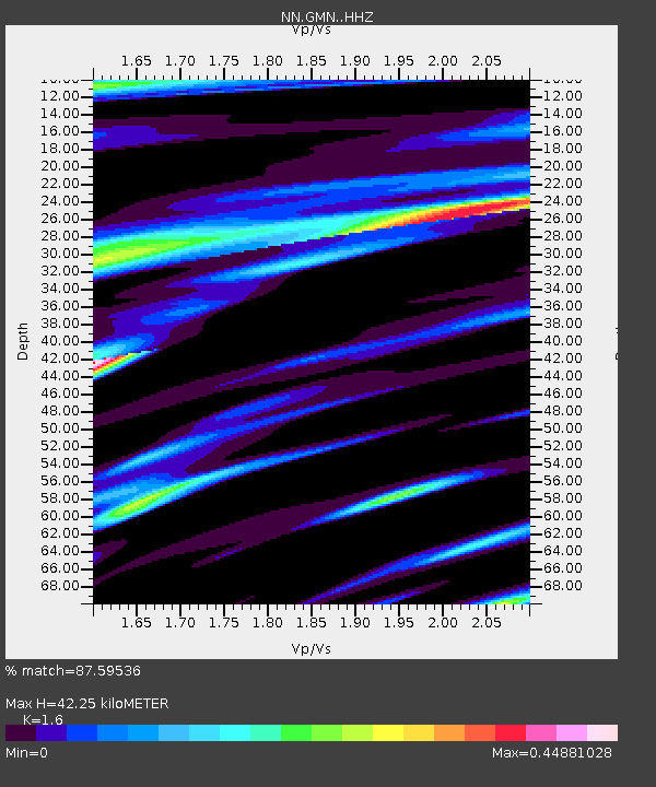
| Estimated Moho Depth: |
42.25 km |
| Estimated Crust Vp/Vs: |
1.60 |
| Assumed Crust Vp: |
6.279 km/s |
| Estimated Crust Vs: |
3.924 km/s |
| Estimated Crust Poisson's Ratio: |
0.18 |
|
| Radial Match: |
87.59536 % |
| Radial Bump: |
400 |
| Transverse Match: |
72.600426 % |
| Transverse Bump: |
400 |
| SOD ConfigId: |
25131211 |
| Insert Time: |
2021-08-28 12:15:05.231 +0000 |
| GWidth: |
2.5 |
| Max Bumps: |
400 |
| Tol: |
0.001 |
|

Signal To Noise
| Channel | StoN | STA | LTA |
| NN:GMN: :HHZ:20210814T12:03:44.589994Z | 43.4187 | 6.2233544E-6 | 1.4333351E-7 |
| NN:GMN: :HHN:20210814T12:03:44.589994Z | 8.59701 | 3.1880256E-6 | 3.708296E-7 |
| NN:GMN: :HHE:20210814T12:03:44.589994Z | 1.1508158 | 1.3677495E-6 | 1.1885043E-6 |
| Arrivals |
| Ps | 4.4 SECOND |
| PpPs | 16 SECOND |
| PsPs/PpSs | 20 SECOND |


