You are here: Home > Network List > NN - Western Great Basin/Eastern Sierra Nevada Stations List
> Station KVN Kaiserville, Nevada w84gm > Earthquake Result Viewer
KVN Kaiserville, Nevada w84gm - Earthquake Result Viewer
| Earthquake location: |
Alaska Peninsula |
| Earthquake latitude/longitude: |
55.2/-157.7 |
| Earthquake time(UTC): |
2021/08/14 (226) 11:57:42 GMT |
| Earthquake Depth: |
4.8 km |
| Earthquake Magnitude: |
6.4 ml |
| Earthquake Catalog/Contributor: |
NEIC PDE/ak |
|
| Network: |
NN Western Great Basin/Eastern Sierra Nevada |
| Station: |
KVN Kaiserville, Nevada w84gm |
| Lat/Lon: |
39.05 N/118.10 W |
| Elevation: |
1829 m |
|
| Distance: |
30.9 deg |
| Az: |
104.934 deg |
| Baz: |
314.706 deg |
| Ray Param: |
0.07927557 |
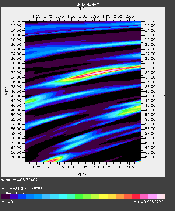
| Estimated Moho Depth: |
31.5 km |
| Estimated Crust Vp/Vs: |
1.93 |
| Assumed Crust Vp: |
6.279 km/s |
| Estimated Crust Vs: |
3.249 km/s |
| Estimated Crust Poisson's Ratio: |
0.32 |
|
| Radial Match: |
86.77484 % |
| Radial Bump: |
295 |
| Transverse Match: |
71.950714 % |
| Transverse Bump: |
400 |
| SOD ConfigId: |
25131211 |
| Insert Time: |
2021-08-28 12:15:08.654 +0000 |
| GWidth: |
2.5 |
| Max Bumps: |
400 |
| Tol: |
0.001 |
|

Signal To Noise
| Channel | StoN | STA | LTA |
| NN:KVN: :HHZ:20210814T12:03:29.593015Z | 38.009182 | 5.8031706E-6 | 1.5267813E-7 |
| NN:KVN: :HHN:20210814T12:03:29.593015Z | 22.141867 | 2.4609194E-6 | 1.1114326E-7 |
| NN:KVN: :HHE:20210814T12:03:29.593015Z | 26.721184 | 2.7453013E-6 | 1.0273876E-7 |
| Arrivals |
| Ps | 5.0 SECOND |
| PpPs | 14 SECOND |
| PsPs/PpSs | 19 SECOND |


