You are here: Home > Network List > NN - Western Great Basin/Eastern Sierra Nevada Stations List
> Station MZPB Montezuma,NV,USA analog reactivation > Earthquake Result Viewer
MZPB Montezuma,NV,USA analog reactivation - Earthquake Result Viewer
| Earthquake location: |
Alaska Peninsula |
| Earthquake latitude/longitude: |
55.2/-157.7 |
| Earthquake time(UTC): |
2021/08/14 (226) 11:57:42 GMT |
| Earthquake Depth: |
4.8 km |
| Earthquake Magnitude: |
6.4 ml |
| Earthquake Catalog/Contributor: |
NEIC PDE/ak |
|
| Network: |
NN Western Great Basin/Eastern Sierra Nevada |
| Station: |
MZPB Montezuma,NV,USA analog reactivation |
| Lat/Lon: |
37.70 N/117.38 W |
| Elevation: |
2371 m |
|
| Distance: |
32.3 deg |
| Az: |
105.972 deg |
| Baz: |
316.034 deg |
| Ray Param: |
0.07875034 |
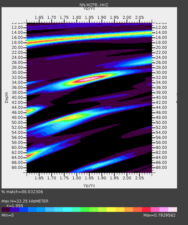
| Estimated Moho Depth: |
32.25 km |
| Estimated Crust Vp/Vs: |
1.86 |
| Assumed Crust Vp: |
6.279 km/s |
| Estimated Crust Vs: |
3.385 km/s |
| Estimated Crust Poisson's Ratio: |
0.30 |
|
| Radial Match: |
88.832306 % |
| Radial Bump: |
266 |
| Transverse Match: |
61.857437 % |
| Transverse Bump: |
400 |
| SOD ConfigId: |
25131211 |
| Insert Time: |
2021-08-28 12:15:19.280 +0000 |
| GWidth: |
2.5 |
| Max Bumps: |
400 |
| Tol: |
0.001 |
|

Signal To Noise
| Channel | StoN | STA | LTA |
| NN:MZPB: :HHZ:20210814T12:03:41.475004Z | 35.228058 | 5.560796E-6 | 1.5785135E-7 |
| NN:MZPB: :HHN:20210814T12:03:41.475004Z | 14.190593 | 2.013273E-6 | 1.4187377E-7 |
| NN:MZPB: :HHE:20210814T12:03:41.475004Z | 10.137768 | 2.4801611E-6 | 2.446457E-7 |
| Arrivals |
| Ps | 4.7 SECOND |
| PpPs | 14 SECOND |
| PsPs/PpSs | 18 SECOND |


