You are here: Home > Network List > O2 - Oklahoma Consolidated Temporary Seismic Networks Stations List
> Station FREE Freedom, Oklahoma, USA > Earthquake Result Viewer
FREE Freedom, Oklahoma, USA - Earthquake Result Viewer
| Earthquake location: |
Alaska Peninsula |
| Earthquake latitude/longitude: |
55.2/-157.7 |
| Earthquake time(UTC): |
2021/08/14 (226) 11:57:42 GMT |
| Earthquake Depth: |
4.8 km |
| Earthquake Magnitude: |
6.4 ml |
| Earthquake Catalog/Contributor: |
NEIC PDE/ak |
|
| Network: |
O2 Oklahoma Consolidated Temporary Seismic Networks |
| Station: |
FREE Freedom, Oklahoma, USA |
| Lat/Lon: |
36.93 N/99.27 W |
| Elevation: |
563 m |
|
| Distance: |
43.1 deg |
| Az: |
90.096 deg |
| Baz: |
314.373 deg |
| Ray Param: |
0.07280991 |
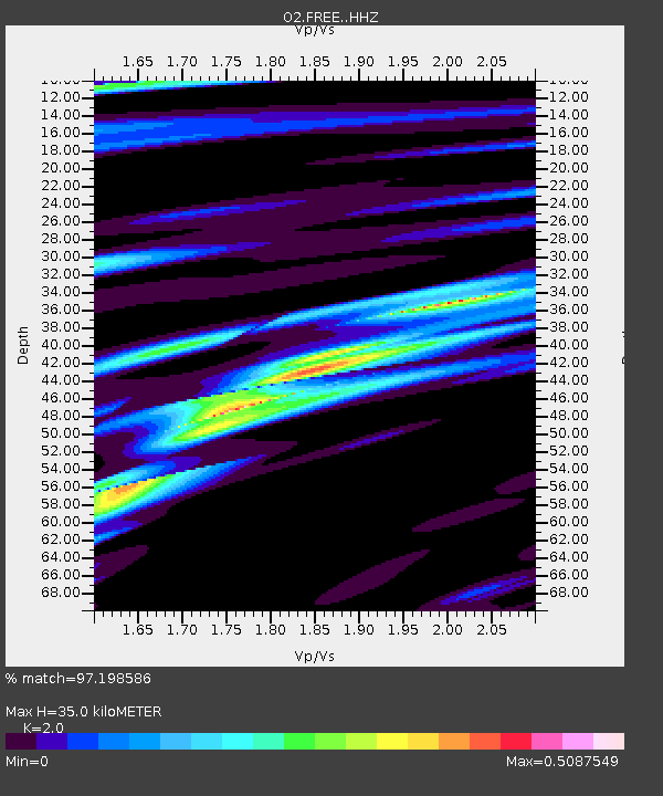
| Estimated Moho Depth: |
35.0 km |
| Estimated Crust Vp/Vs: |
2.00 |
| Assumed Crust Vp: |
6.426 km/s |
| Estimated Crust Vs: |
3.213 km/s |
| Estimated Crust Poisson's Ratio: |
0.33 |
|
| Radial Match: |
97.198586 % |
| Radial Bump: |
257 |
| Transverse Match: |
97.19857 % |
| Transverse Bump: |
257 |
| SOD ConfigId: |
25131211 |
| Insert Time: |
2021-08-28 12:16:07.932 +0000 |
| GWidth: |
2.5 |
| Max Bumps: |
400 |
| Tol: |
0.001 |
|

Signal To Noise
| Channel | StoN | STA | LTA |
| O2:FREE: :HHZ:20210814T12:05:12.510007Z | 18.351067 | 1.7355449E-6 | 9.45746E-8 |
| $trig.getChannelId() | $trig.getValue() | $trig.getSTA() | $trig.getLTA() |
| O2:FREE: :HHE:20210814T12:05:12.510007Z | 5.473806 | 8.611517E-7 | 1.573223E-7 |
| Arrivals |
| Ps | 5.8 SECOND |
| PpPs | 15 SECOND |
| PsPs/PpSs | 21 SECOND |


