You are here: Home > Network List > NM - Cooperative New Madrid Seismic Network Stations List
> Station USIN Univ. of Southern Indiana, Evansville, IN > Earthquake Result Viewer
USIN Univ. of Southern Indiana, Evansville, IN - Earthquake Result Viewer
| Earthquake location: |
Southern Peru |
| Earthquake latitude/longitude: |
-15.6/-73.2 |
| Earthquake time(UTC): |
2006/09/30 (273) 16:26:56 GMT |
| Earthquake Depth: |
107 km |
| Earthquake Magnitude: |
5.6 MB, 6.0 MW, 5.9 MW |
| Earthquake Catalog/Contributor: |
WHDF/NEIC |
|
| Network: |
NM Cooperative New Madrid Seismic Network |
| Station: |
USIN Univ. of Southern Indiana, Evansville, IN |
| Lat/Lon: |
37.97 N/87.67 W |
| Elevation: |
1707 m |
|
| Distance: |
55.0 deg |
| Az: |
346.01 deg |
| Baz: |
162.857 deg |
| Ray Param: |
0.06476077 |
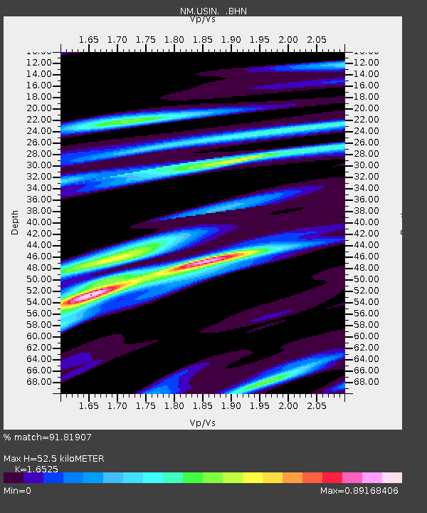
| Estimated Moho Depth: |
52.5 km |
| Estimated Crust Vp/Vs: |
1.65 |
| Assumed Crust Vp: |
6.444 km/s |
| Estimated Crust Vs: |
3.899 km/s |
| Estimated Crust Poisson's Ratio: |
0.21 |
|
| Radial Match: |
91.81907 % |
| Radial Bump: |
400 |
| Transverse Match: |
68.82164 % |
| Transverse Bump: |
400 |
| SOD ConfigId: |
2564 |
| Insert Time: |
2010-03-09 11:39:45.289 +0000 |
| GWidth: |
2.5 |
| Max Bumps: |
400 |
| Tol: |
0.001 |
|

Signal To Noise
| Channel | StoN | STA | LTA |
| NM:USIN: :BHN:20060930T16:35:45.668022Z | 4.532718 | 7.3098846E-7 | 1.6126934E-7 |
| NM:USIN: :BHE:20060930T16:35:45.668022Z | 1.4681379 | 1.9660335E-7 | 1.3391342E-7 |
| NM:USIN: :BHZ:20060930T16:35:45.668022Z | 9.181025 | 1.3466396E-6 | 1.466764E-7 |
| Arrivals |
| Ps | 5.6 SECOND |
| PpPs | 20 SECOND |
| PsPs/PpSs | 26 SECOND |


