You are here: Home > Network List > NM - Cooperative New Madrid Seismic Network Stations List
> Station USIN Univ. of Southern Indiana, Evansville, IN > Earthquake Result Viewer
USIN Univ. of Southern Indiana, Evansville, IN - Earthquake Result Viewer
| Earthquake location: |
Near Coast Of Peru |
| Earthquake latitude/longitude: |
-13.5/-76.7 |
| Earthquake time(UTC): |
2006/10/20 (293) 10:48:56 GMT |
| Earthquake Depth: |
23 km |
| Earthquake Magnitude: |
5.9 MB, 6.6 MS, 6.7 MW, 6.6 MW |
| Earthquake Catalog/Contributor: |
WHDF/NEIC |
|
| Network: |
NM Cooperative New Madrid Seismic Network |
| Station: |
USIN Univ. of Southern Indiana, Evansville, IN |
| Lat/Lon: |
37.97 N/87.67 W |
| Elevation: |
1707 m |
|
| Distance: |
52.2 deg |
| Az: |
349.005 deg |
| Baz: |
166.422 deg |
| Ray Param: |
0.06689266 |
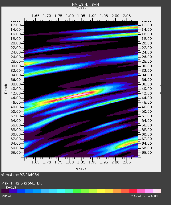
| Estimated Moho Depth: |
42.5 km |
| Estimated Crust Vp/Vs: |
1.84 |
| Assumed Crust Vp: |
6.444 km/s |
| Estimated Crust Vs: |
3.502 km/s |
| Estimated Crust Poisson's Ratio: |
0.29 |
|
| Radial Match: |
92.966064 % |
| Radial Bump: |
319 |
| Transverse Match: |
64.43516 % |
| Transverse Bump: |
400 |
| SOD ConfigId: |
2665 |
| Insert Time: |
2010-03-09 11:39:49.891 +0000 |
| GWidth: |
2.5 |
| Max Bumps: |
400 |
| Tol: |
0.001 |
|

Signal To Noise
| Channel | StoN | STA | LTA |
| NM:USIN: :BHN:20061020T10:57:33.89501Z | 6.1977487 | 1.645854E-6 | 2.6555676E-7 |
| NM:USIN: :BHE:20061020T10:57:33.89501Z | 1.5464945 | 3.5402556E-7 | 2.2892132E-7 |
| NM:USIN: :BHZ:20061020T10:57:33.89501Z | 9.184026 | 2.8053707E-6 | 3.05462E-7 |
| Arrivals |
| Ps | 5.8 SECOND |
| PpPs | 18 SECOND |
| PsPs/PpSs | 24 SECOND |


