You are here: Home > Network List > O2 - Oklahoma Consolidated Temporary Seismic Networks Stations List
> Station ROSS Rosston, Oklahoma, USA > Earthquake Result Viewer
ROSS Rosston, Oklahoma, USA - Earthquake Result Viewer
| Earthquake location: |
Alaska Peninsula |
| Earthquake latitude/longitude: |
55.2/-157.7 |
| Earthquake time(UTC): |
2021/08/14 (226) 11:57:42 GMT |
| Earthquake Depth: |
4.8 km |
| Earthquake Magnitude: |
6.4 ml |
| Earthquake Catalog/Contributor: |
NEIC PDE/ak |
|
| Network: |
O2 Oklahoma Consolidated Temporary Seismic Networks |
| Station: |
ROSS Rosston, Oklahoma, USA |
| Lat/Lon: |
36.95 N/99.87 W |
| Elevation: |
607 m |
|
| Distance: |
42.7 deg |
| Az: |
90.569 deg |
| Baz: |
314.362 deg |
| Ray Param: |
0.07303235 |
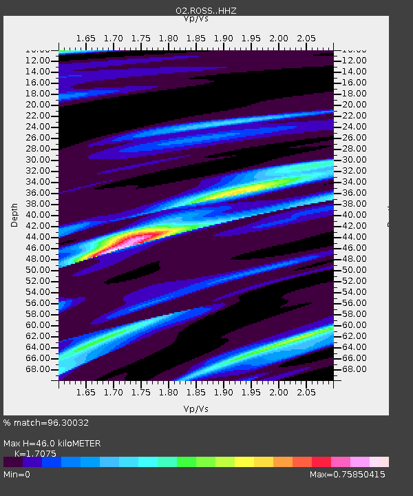
| Estimated Moho Depth: |
46.0 km |
| Estimated Crust Vp/Vs: |
1.71 |
| Assumed Crust Vp: |
6.426 km/s |
| Estimated Crust Vs: |
3.763 km/s |
| Estimated Crust Poisson's Ratio: |
0.24 |
|
| Radial Match: |
96.30032 % |
| Radial Bump: |
264 |
| Transverse Match: |
94.31668 % |
| Transverse Bump: |
400 |
| SOD ConfigId: |
25131211 |
| Insert Time: |
2021-08-28 12:16:45.173 +0000 |
| GWidth: |
2.5 |
| Max Bumps: |
400 |
| Tol: |
0.001 |
|

Signal To Noise
| Channel | StoN | STA | LTA |
| O2:ROSS: :HHZ:20210814T12:05:09.649991Z | 17.812775 | 1.7674836E-6 | 9.9225616E-8 |
| O2:ROSS: :HHN:20210814T12:05:09.649991Z | 4.2510476 | 6.8959343E-7 | 1.6221728E-7 |
| O2:ROSS: :HHE:20210814T12:05:09.649991Z | 3.7355685 | 1.2060715E-6 | 3.2286155E-7 |
| Arrivals |
| Ps | 5.4 SECOND |
| PpPs | 18 SECOND |
| PsPs/PpSs | 24 SECOND |


